Human Geography: sources and permissions
Original questions and drawings by Practice Dojo. This ledger records the source material, dates, reuse basis and adaptations for the revised visual bank. It does not imply endorsement by the source organizations or College Board.
Photographs retain their individual licenses. Numerical facts have been independently charted or tabulated; published report artwork is not reproduced unless expressly identified as a federal source panel. Conceptual models are labeled as models rather than observed data.
Prepared October 22, 2026. Generalized Natural Earth de facto boundaries are reference geometry and do not settle territorial claims. Older observations are deliberately dated historical examples, not representations of present conditions.
UNIT 1 · county
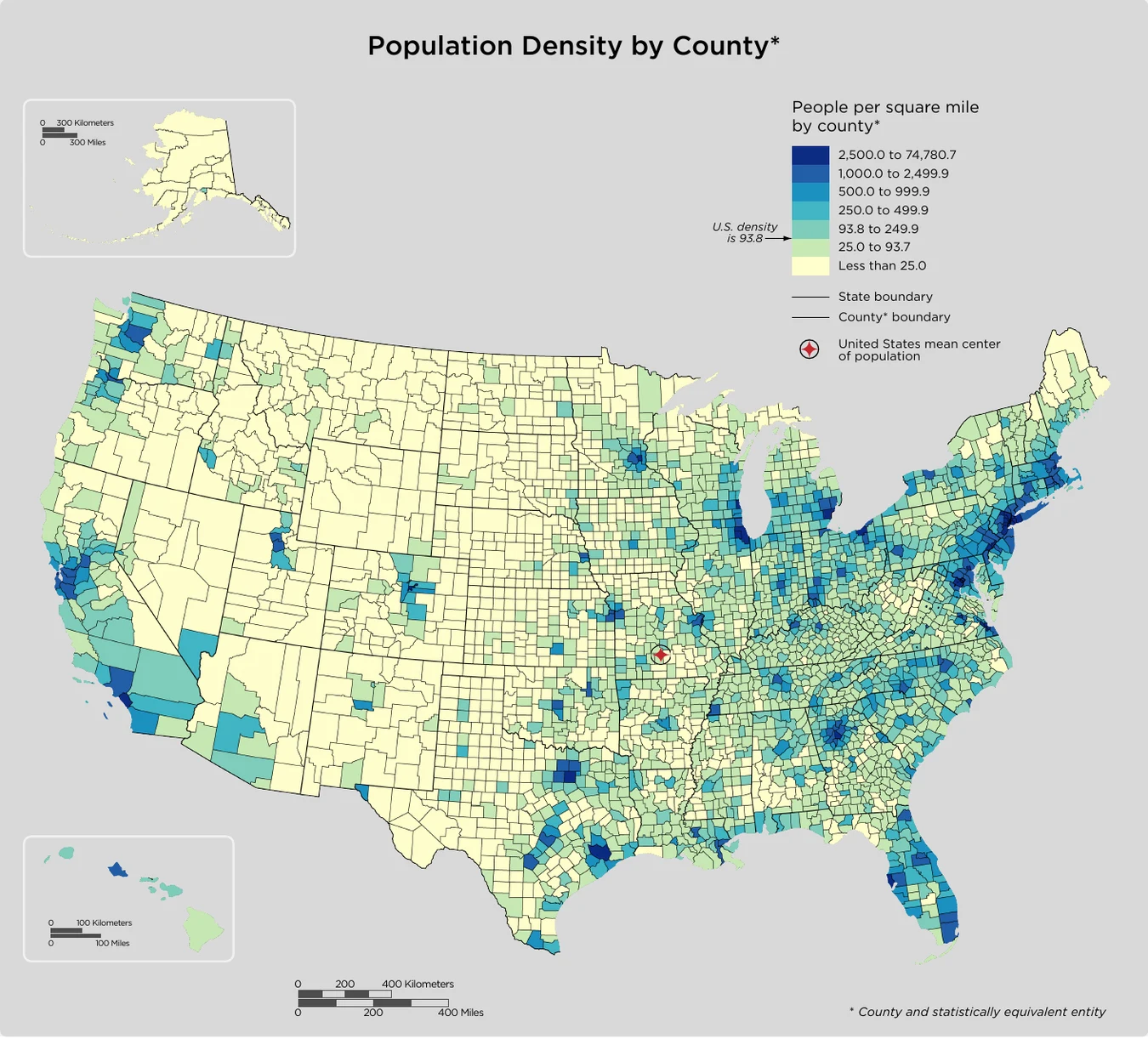
United States · population density by county, 2020
- Credit and adaptations
- U.S. Census Bureau, 2020 Census DHC; profile published December 2023. Map panel excerpted; legend, insets and scales retained.
- Reuse basis
- Public-domain U.S. federal work; source credit retained. Resized/re-encoded; scene unchanged.
- Source
- Original source
- Packaged asset SHA-256
- 8144f828ad191c6f314fbb6cea50b4332e5d4af4ab9804b11e2df063966fb648
UNIT 1 · aral
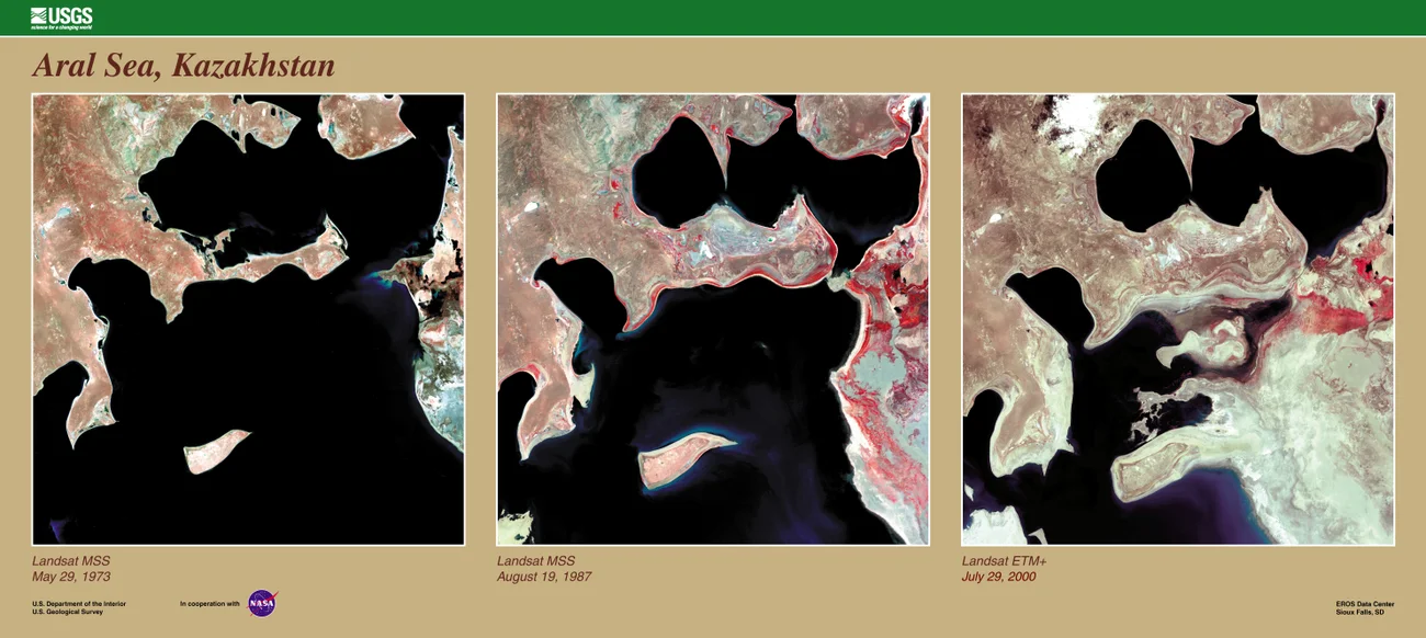
Aral Sea · Landsat observations, 1973–2000
- Credit and adaptations
- USGS EROS Data Center / Landsat science team, via NASA Earth Observatory. Image-panel labels: May 29, 1973; August 19, 1987; July 29, 2000. Page/download metadata give different early acquisition dates, so the printed panel labels govern this credit.
- Reuse basis
- Public-domain U.S. federal work; source credit retained. Resized/re-encoded; scene unchanged.
- Source
- Original source
- Packaged asset SHA-256
- 57147b1aae76d08a86f8a554fa3333ed4cf9c6b1a2949599d3e31ff72788e0cd
UNIT 1 · projections
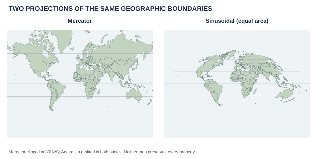
World map projections · Mercator and sinusoidal, same country boundaries
- Credit and adaptations
- Practice Dojo maps from Natural Earth 1:110m country geometries, repository snapshot ca96624. Mercator and sinusoidal projections calculated from coordinates; Mercator clipped at 80°N and 80°S, Antarctica omitted.
- Reuse basis
- Natural Earth public-domain country boundaries; original thematic rendering. Generalized de facto lines are not an endorsement of claims.
- Source
- Original source
- Packaged asset SHA-256
- de3a3c4b341bec5e959f0d255f2ee998a98be38a91b252baf0fb9f82cbc245bd
UNIT 1 · state-totals
Selected U.S. states · resident population, April 1, 2020
- Credit and adaptations
- U.S. Census Bureau, 2020 Census apportionment, Table 2. Selected rows; resident population, not apportionment population.
- Reuse basis
- Selected numerical facts independently re-tabulated or charted; source artwork, prose and logos not reproduced.
- Source
- Original source
UNIT 1 · national-pop
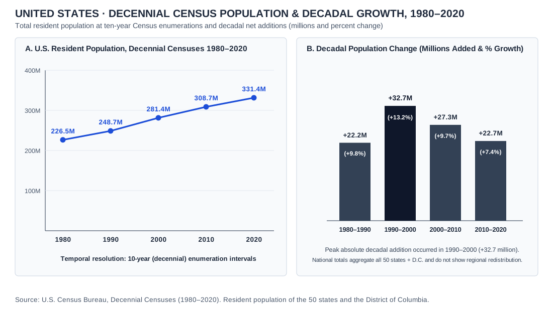
United States · decennial census population and decadal growth, 1980–2020
- Credit and adaptations
- U.S. Census Bureau, 2020 national profile: historical population totals. Original chart; resident counts for 50 states and DC.
- Reuse basis
- Selected numerical facts independently re-tabulated or charted; source artwork, prose and logos not reproduced.
- Source
- Original source
- Packaged asset SHA-256
- 3f55f54bb63c892dc09ab3a4a6e020ff154e2544f55032394ec7af71f436e7e7
UNIT 1 · africa-regions
Africa · statistical subregions
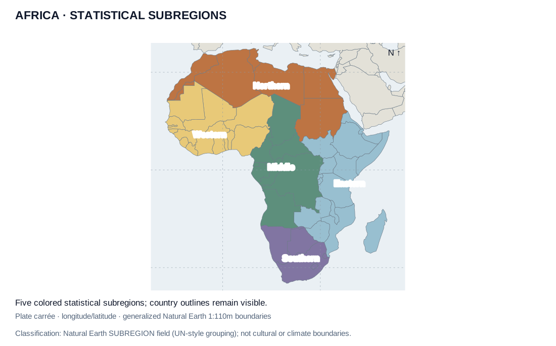
- Credit and adaptations
- Original map from Natural Earth country geometries and SUBREGION attributes, which use UN-style statistical groupings. Dataset accessed October 2026.
- Reuse basis
- Natural Earth public-domain country boundaries; original thematic rendering. Generalized de facto lines are not an endorsement of claims.
- Source
- Original source
- Packaged asset SHA-256
- 586093188696cf9df2fe253f4247e332263044d13a637e03f234c0f9ca407fc4
UNIT 1 · us-census-regions
United States · population by Census region, 1970 and 2020
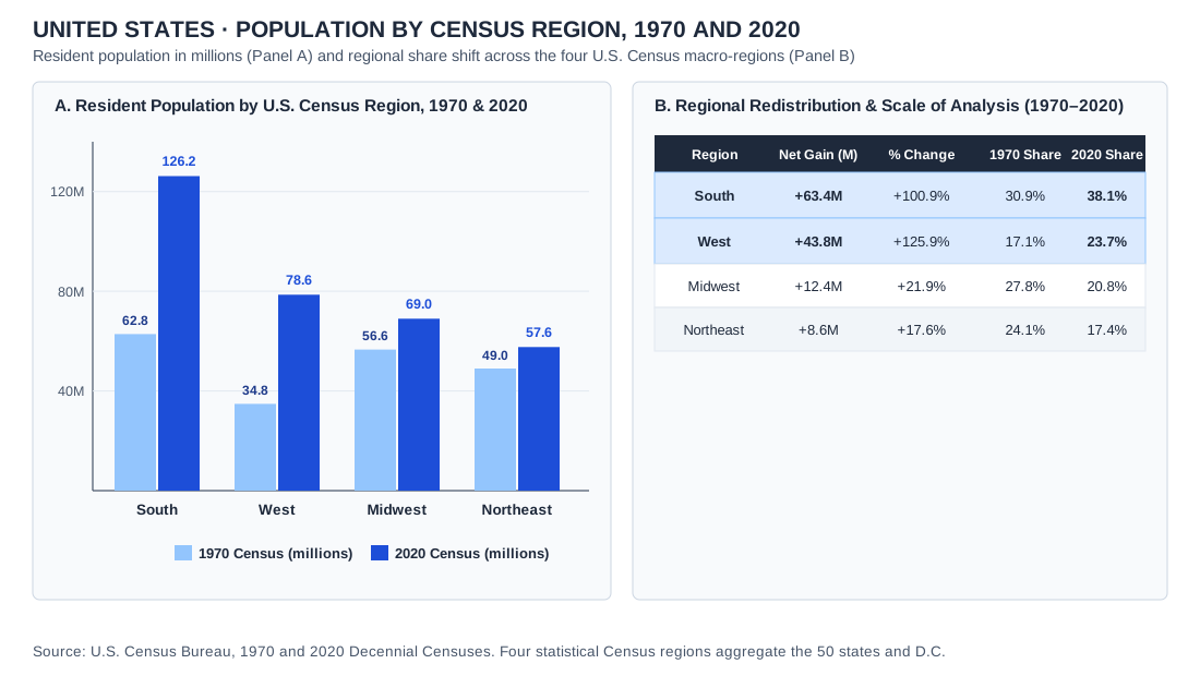
- Credit and adaptations
- Data: U.S. Census Bureau, 1970 and 2020 decennial censuses; four Census regions covering the 50 states and D.C. Values in millions. Practice Dojo chart.
- Reuse basis
- Public-domain U.S. Census data, independently charted by Practice Dojo.
- Source
- Original source
- Packaged asset SHA-256
- 32894fcb066e6d84ec22602eb91fa98514fd49f58d355bf5ff0f34561e7d2523
UNIT 1 · global-urban-share-map
World · urban share of total population by country, 2023
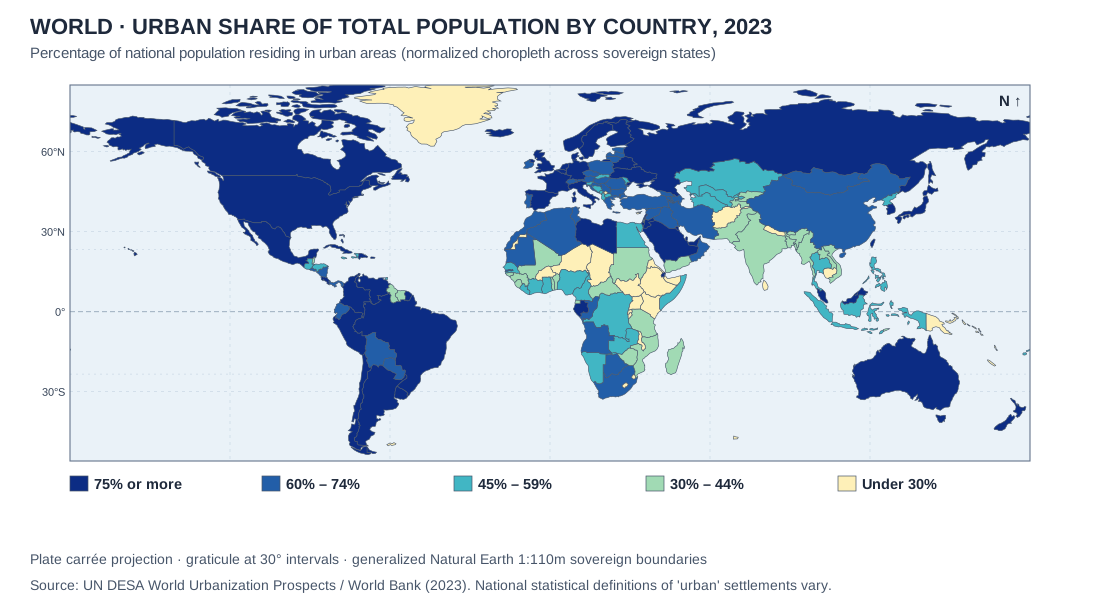
- Credit and adaptations
- UN DESA World Urbanization Prospects / World Bank WDI (2023) on Natural Earth 1:110m boundaries.
- Reuse basis
- Natural Earth public-domain geometry; UN/World Bank statistical series charted by Practice Dojo.
- Source
- Original source
- Packaged asset SHA-256
- 04eb1cbfde8a08f507d04153eef3aa2670abda33edef1e6369a6e4a1165d4d72
UNIT 2 · dtm
Demographic and epidemiologic transition · five-stage model
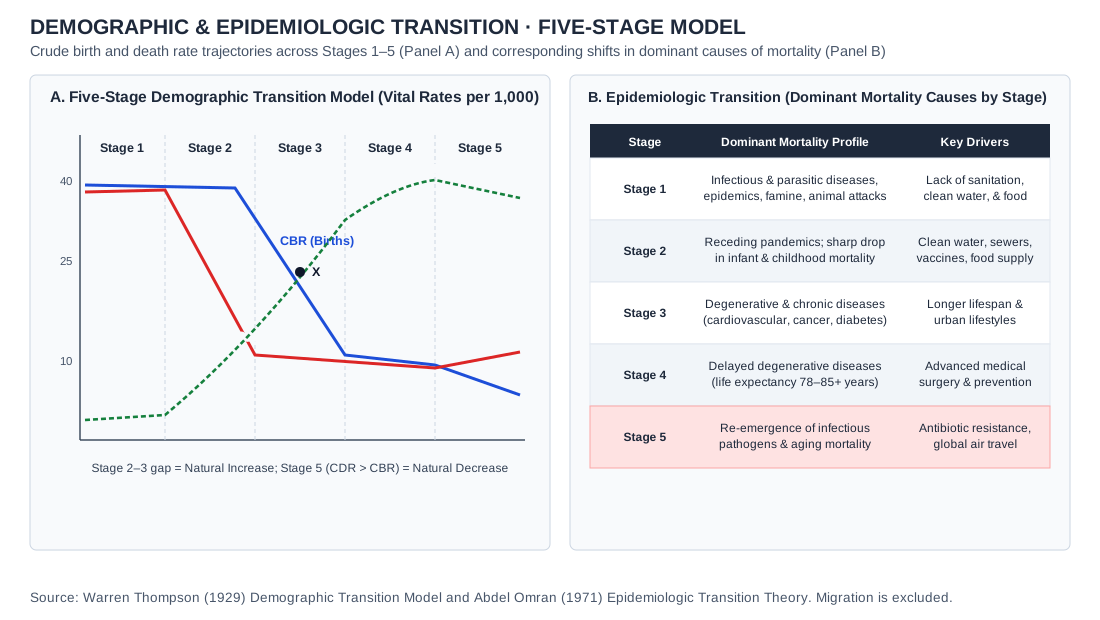
- Credit and adaptations
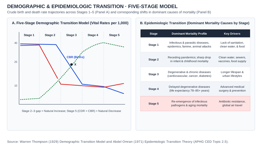
- Practice Dojo drawing of the standard five-stage demographic transition model (after Warren Thompson, 1929) and Abdel Omran’s epidemiologic transition theory (1971). Qualitative model; curves are not observations or a forecast for a particular country. No migration assumed.
- Reuse basis
- Original Practice Dojo drawing of a standard concept; no third-party artwork reproduced.
- Source
- Original source
- Packaged asset SHA-256
- d014165e5f50a7da1eebaff8bfb6dd28a228d89fd75e750801ae86fb9f6c74d9
UNIT 2 · pyramid
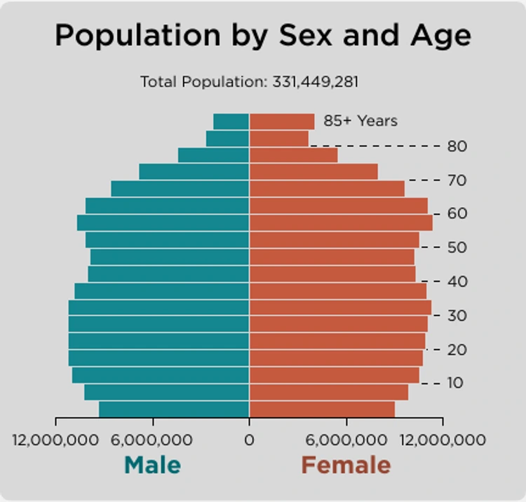
United States · population by sex and age, 2020
- Credit and adaptations
- U.S. Census Bureau, 2020 Census DHC national profile. Age/sex panel excerpted, retaining its axes and total.
- Reuse basis
- Public-domain U.S. federal work; source credit retained. Resized/re-encoded; scene unchanged.
- Source
- Original source
- Packaged asset SHA-256
- c7636a8a2ee4c335b0fde188541cf73c8007df01bed6429fba9c8e53a9ad019e
UNIT 2 · aging
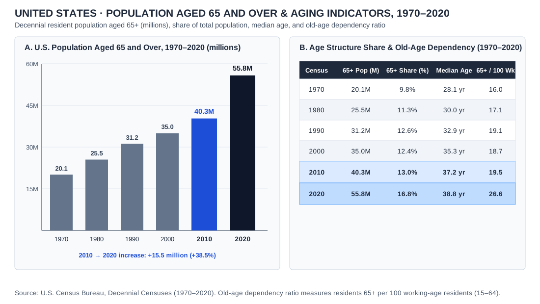
United States · population aged 65 and over and aging indicators, 1970–2020
- Credit and adaptations
- Data: U.S. Census Bureau, decennial censuses 1970–2020, and The Older Population: 2020 (2023). Rounded totals; old-age dependency ratio is residents 65+ per 100 aged 15–64. Practice Dojo chart.
- Reuse basis
- Selected numerical facts independently re-tabulated or charted; source artwork, prose and logos not reproduced.
- Source
- Original source
- Packaged asset SHA-256
- 28928323620e179b9d5e40f0b584d5c501695d418490aabcab82eedb2266e586
UNIT 2 · refugees
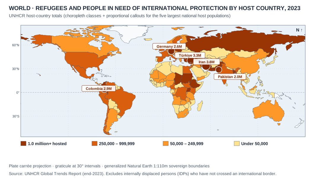
World · refugees and people in need of international protection by host country, end of 2023
- Credit and adaptations
- UNHCR, Global Trends 2023, Figure 9 and country-of-asylum discussion; five rounded host counts. Original map on Natural Earth boundaries.
- Reuse basis
- Selected numerical facts independently re-tabulated or charted; source artwork, prose and logos not reproduced. Natural Earth public-domain country boundaries; original thematic rendering. Generalized de facto lines are not an endorsement of claims.
- Source
- Original source
- Scope and qualifications
- Categories include refugees, refugee-like situations and other people in need of international protection; not all migrants or all internally displaced people. Rounded values are not exact counts.
- Packaged asset SHA-256
- 516ee367a97d9e8c622cb2f2c81d6847ea8758e7a0621069950d37e36bd810da
UNIT 2 · foreignborn
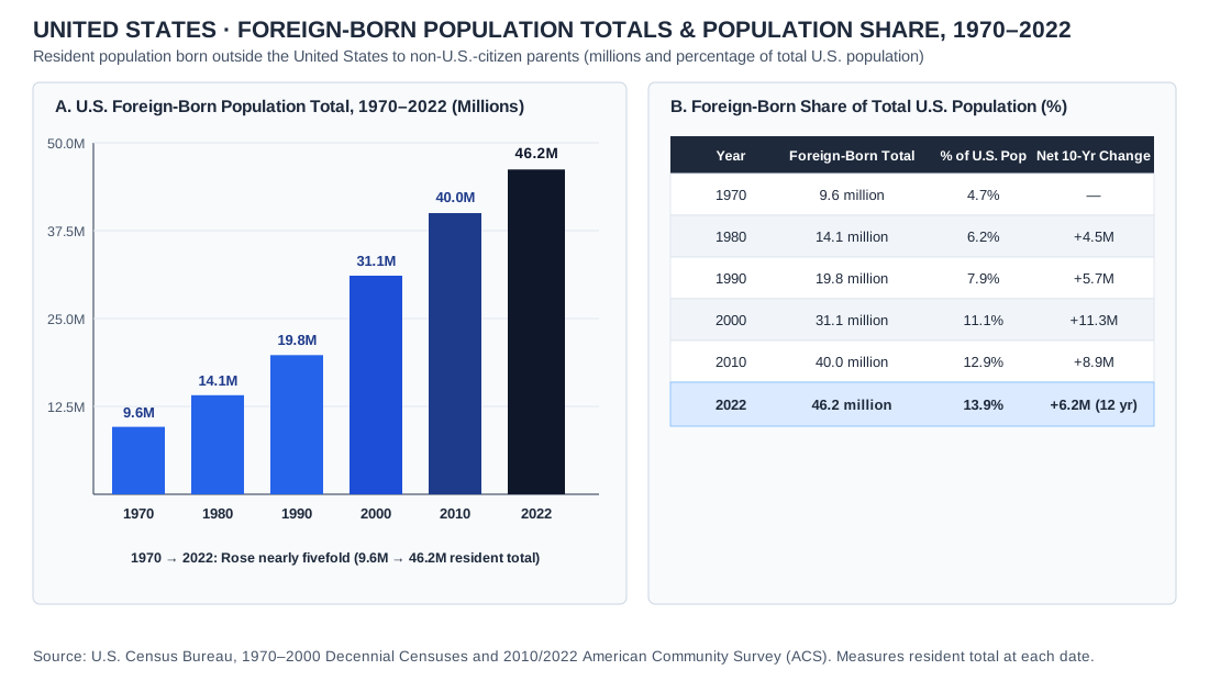
United States · foreign-born population totals and share, 1970–2022
- Credit and adaptations
- U.S. Census Bureau, ACSBR-019, April 2024, Figure 1. Historical censuses and 2010/2022 ACS; rounded figures.
- Reuse basis
- Selected numerical facts independently re-tabulated or charted; source artwork, prose and logos not reproduced.
- Source
- Original source
- Packaged asset SHA-256
- d26e3f8187c7c4fe39c6b91d1545f1a9b8abb220a81bc72e3c4c41a1e43f83c1
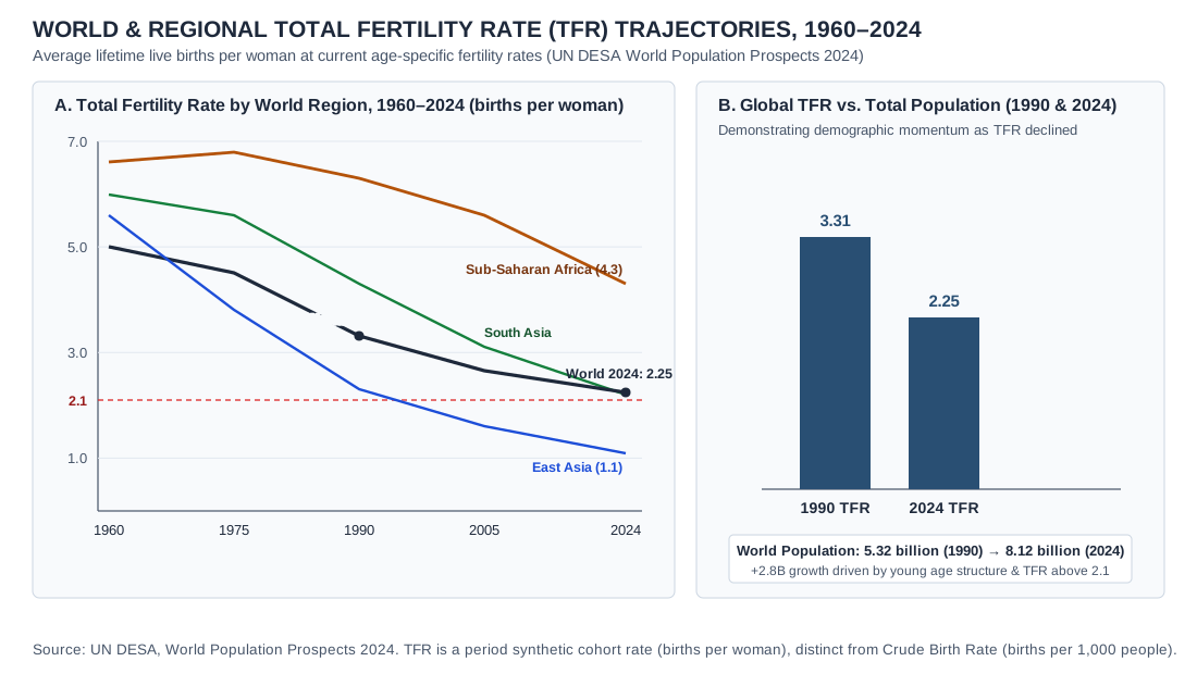
UNIT 2 · fertility
World and regional total fertility rate trajectories, 1960–2024
- Credit and adaptations
- Data: UN DESA Population Division, World Population Prospects 2024. Regional lines are rounded estimates. Practice Dojo chart.
- Reuse basis
- Selected numerical facts independently re-tabulated or charted; source artwork, prose and logos not reproduced.
- Source
- Original source
- Packaged asset SHA-256
- 1b5201972210e75af21dedd8c81825fc800ca514b446d874fc3ccf77c2089312
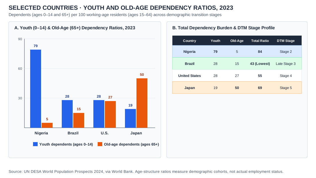
UNIT 2 · dependency-ratios-chart
Selected countries · youth and old-age dependency ratios, 2023
- Credit and adaptations
- Practice Dojo chart using UN DESA World Population Prospects 2024 data (also published by the World Bank); dependency ratios per 100 persons aged 15–64.
- Reuse basis
- UN statistical series independently charted by Practice Dojo.
- Source
- Original source
- Packaged asset SHA-256
- dbd2ef5a1b8c6b9cd2a442f17d4b6e4148823f75478ce006d6b6120baa03b00c
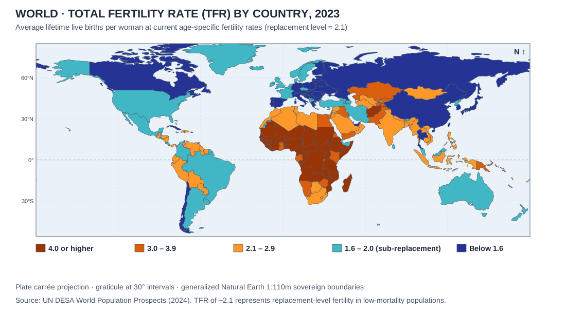
UNIT 2 · global-tfr-map
World · total fertility rate by country, 2023
- Credit and adaptations
- UN DESA, World Population Prospects 2024 on Natural Earth 1:110m boundaries.
- Reuse basis
- Natural Earth public-domain geometry; UN statistical data charted by Practice Dojo.
- Source
- Original source
- Packaged asset SHA-256
- b1942313e87ddc4a047e28b86b01ac130c59f7399f3b34d12fba94171022f98f
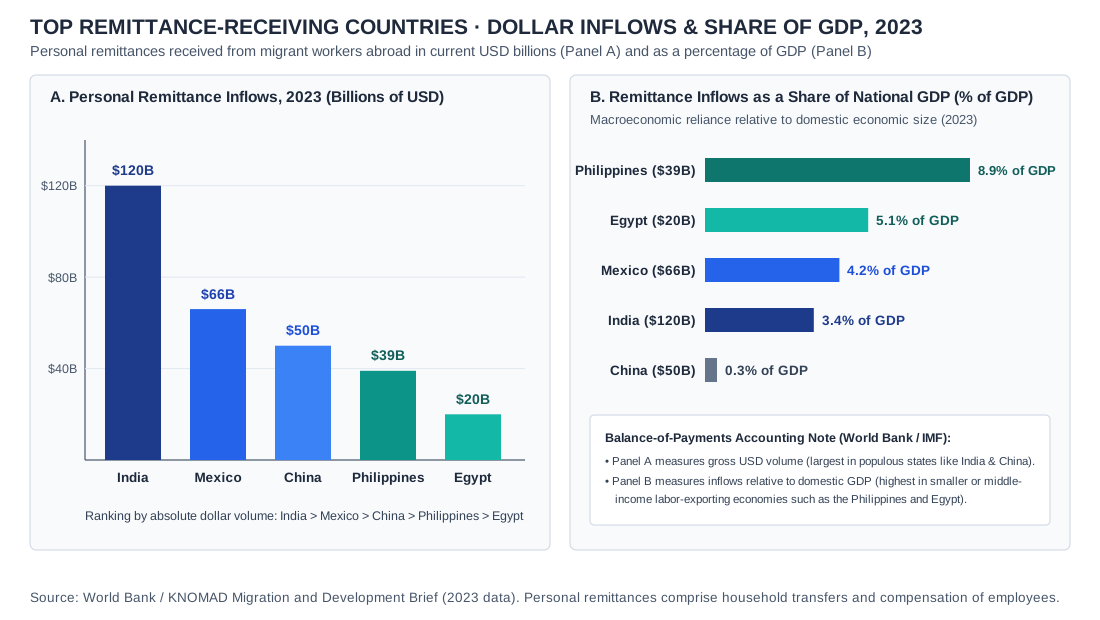
UNIT 2 · remittances-chart
Top remittance-receiving countries · inflows and share of GDP, 2023
- Credit and adaptations
- World Bank / KNOMAD Migration and Development Brief 40 (June 2024). Billions of current US dollars.
- Reuse basis
- World Bank data independently charted by Practice Dojo.
- Source
- Original source
- Packaged asset SHA-256
- 0f1f4215e6dd9404db2433e251c98cdb7fe62eed78a1b9410cfa04a0f8caea28
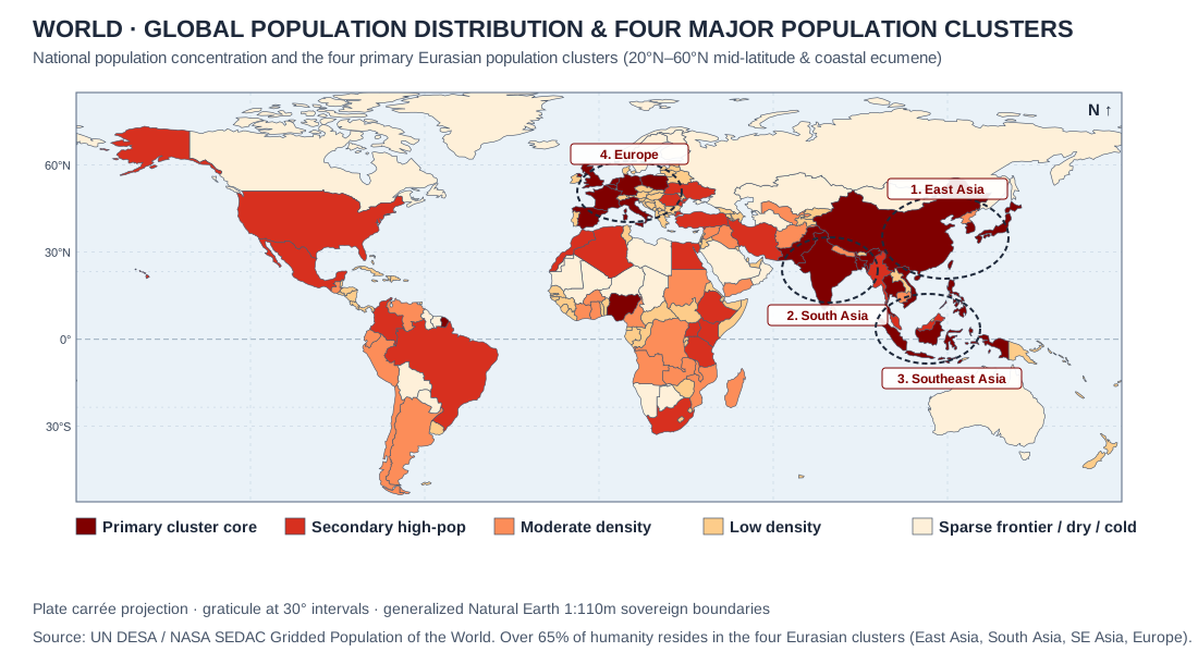
UNIT 2 · ecumene-clusters
World · Global population distribution and the four primary population clusters · UN DESA / NASA SEDAC
- Credit and adaptations
- Practice Dojo original cartographic and analytical exhibit aligned to APHG CED Topic 2.1. World · Global population distribution and the four primary population clusters · UN DESA / NASA SEDAC.
- Reuse basis
- Original vector diagram / Natural Earth 1:110m public-domain geometry and documented public statistical series.
- Packaged asset SHA-256
- e89ed37a87d857a9d6bdb81486819cb45f8c9d51b29073e45219eeb630eaed10
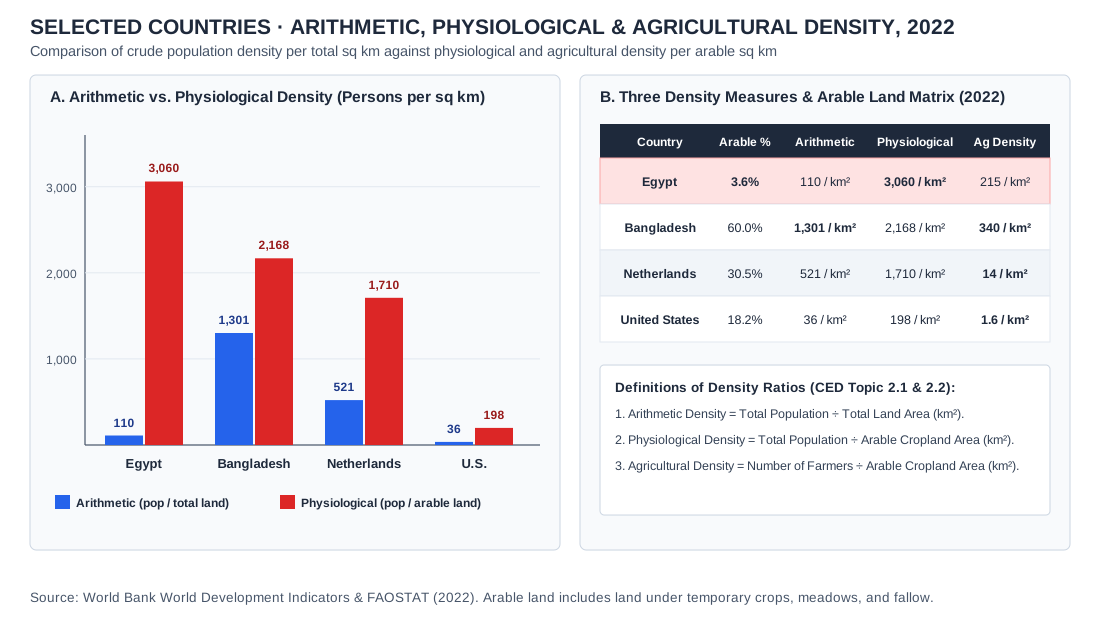
UNIT 2 · density-comparison
Selected countries · Arithmetic, physiological, and agricultural density, 2022 · World Bank / FAOSTAT
- Credit and adaptations
- Practice Dojo original cartographic and analytical exhibit aligned to APHG CED Topic 2.2. Selected countries · Arithmetic, physiological, and agricultural density, 2022 · World Bank / FAOSTAT.
- Reuse basis
- Original vector diagram / Natural Earth 1:110m public-domain geometry and documented public statistical series.
- Packaged asset SHA-256
- 1c7a9560792ecbc892a9c8b9cc9eab01fb6b83584c42291d17771356db6eed50
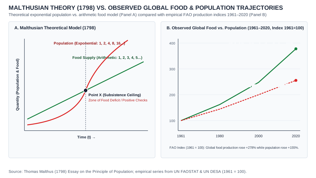
UNIT 2 · malthusian-curves
Malthusian theory (1798) vs. observed global food and population trajectories (1961–2020, FAO index 1961 = 100)
- Credit and adaptations
- Practice Dojo original cartographic and analytical exhibit aligned to APHG CED Topic 2.6. Malthusian theory (1798) vs. observed global food and population trajectories (1961–2020, FAO index 1961 = 100).
- Reuse basis
- Original vector diagram / Natural Earth 1:110m public-domain geometry and documented public statistical series.
- Packaged asset SHA-256
- cea4c33f99575582e2fc670baf23d952eb6d52999d9bcb717a1a78ae610b729a
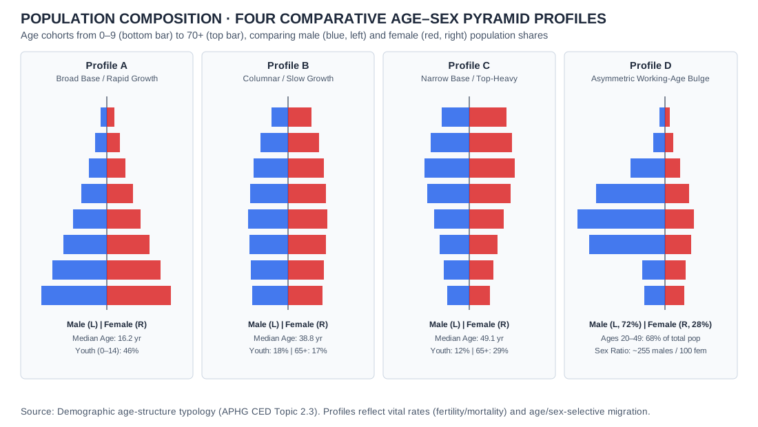
UNIT 2 · population-pyramids-four-stage
Comparative age-sex population pyramids illustrating Stage 2 expansive growth (Niger), Stage 4 columnar stability (United States), Stage 5 constrictive aging (Japan), and male labor-migration asymmetry (Qatar)
- Credit and adaptations
- Practice Dojo original cartographic and analytical exhibit aligned to APHG CED Topic 2.3. Comparative age-sex population pyramids illustrating Stage 2 expansive growth (Niger), Stage 4 columnar stability (United States), Stage 5 constrictive aging (Japan), and male labor-migration asymmetry (Qatar).
- Reuse basis
- Original vector diagram / Natural Earth 1:110m public-domain geometry and documented public statistical series.
- Packaged asset SHA-256
- f8719e463d5a215ef8929e05da0d0436c901dbc0617f6565d44f6353ad1a8f04
UNIT 2 · epidemiologic-demographic-transition
Five-stage Demographic Transition Model (vital rates per 1,000) paired with Abdel Omran's Epidemiologic Transition matrix of dominant mortality causes across Stages 1–5
- Credit and adaptations
- Practice Dojo original cartographic and analytical exhibit aligned to APHG CED Topic 2.5. Five-stage Demographic Transition Model (vital rates per 1,000) paired with Abdel Omran's Epidemiologic Transition matrix of dominant mortality causes across Stages 1–5.
- Reuse basis
- Original vector diagram / Natural Earth 1:110m public-domain geometry and documented public statistical series.
- Packaged asset SHA-256
- 5b182a647547852788e110e5e6bab102fafd267b90891d1b918028289acfdb1c
UNIT 3 · chinatown
San Francisco · Dragon Gate cultural landscape, 2010

- Credit and adaptations
- Chensiyuan, 2010, 1 chinatown san francisco arch gateway.JPG, via Wikimedia Commons. Resized/re-encoded; scene unchanged.
- Reuse basis
- CC BY-SA 4.0; photograph remains under that license.
- Source
- Original source · License
- Packaged asset SHA-256
- 2980cec89e7c908d17e7664eac037f924bb565953e5b59603881a8e3eb66efe4
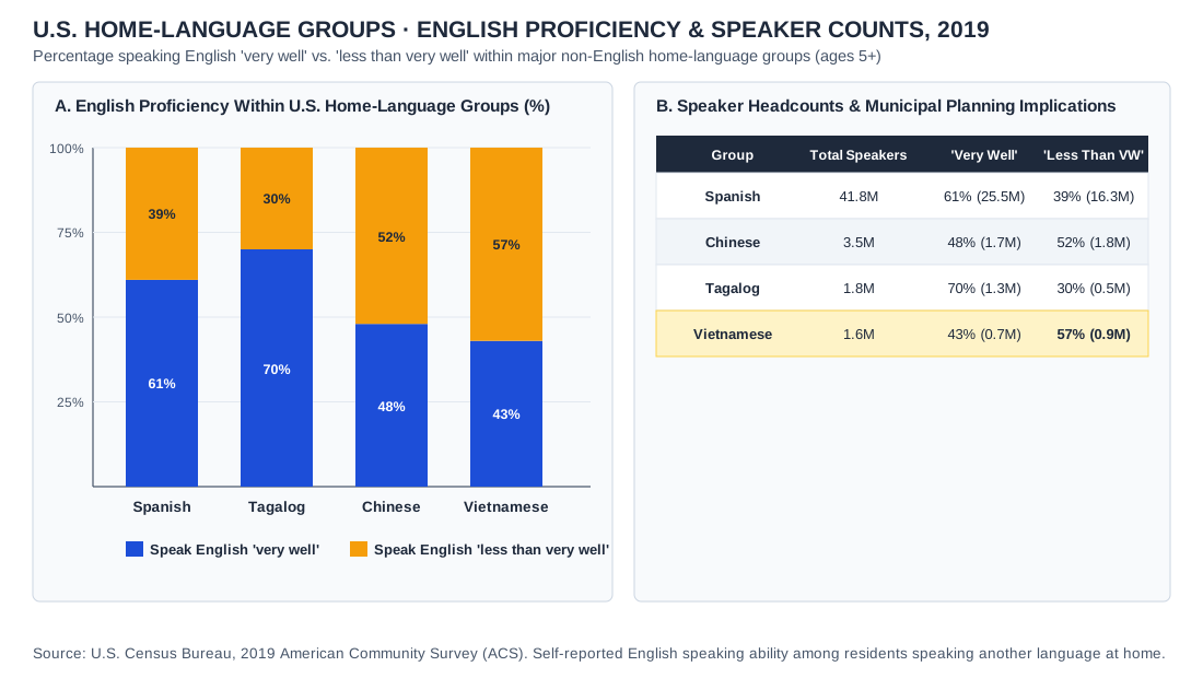
UNIT 3 · english-proficiency
U.S. home-language groups · English proficiency and speaker counts, 2019
- Credit and adaptations
- Data: U.S. Census Bureau, Language Use in the United States: 2019 (American Community Survey); four language groups. Counts in Panel B are rounded and calculated from the reported percentages. Practice Dojo chart.
- Reuse basis
- Selected numerical facts independently re-tabulated or charted; source artwork, prose and logos not reproduced.
- Source
- Original source
- Packaged asset SHA-256
- 7263aa653526c692872ce10b0e05b9d506db104528921343ae45d012f1da6235
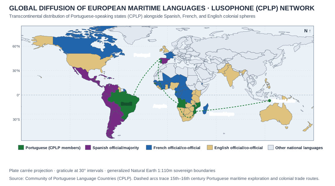
UNIT 3 · lusophone
Lusophone (CPLP) network and other European maritime language spheres
- Credit and adaptations
- CPLP official member list, accessed October 2026. Original Practice Dojo map from Natural Earth public-domain geometries, with Spanish, French and English official-language spheres shown for comparison and schematic routes of Portuguese maritime exploration.
- Reuse basis
- Selected numerical facts independently re-tabulated or charted; source artwork, prose and logos not reproduced. Natural Earth public-domain country boundaries; original thematic rendering. Generalized de facto lines are not an endorsement of claims.
- Source
- Original source
- Packaged asset SHA-256
- 7d7370b27b8852315cf456432932c20c8520396347e521e8de22950b87b7eb0e
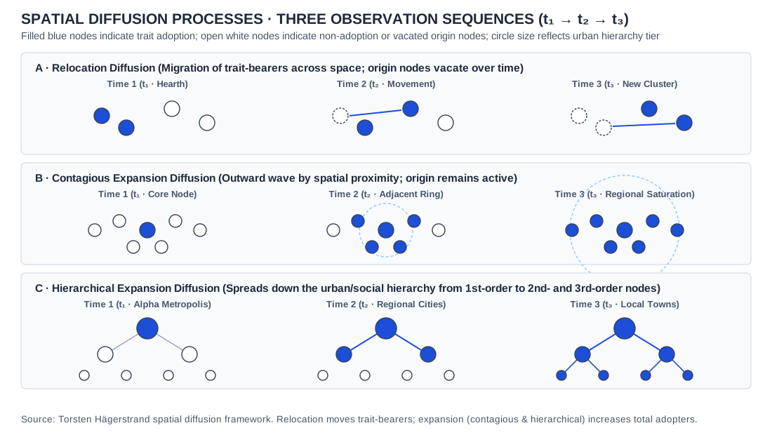
UNIT 3 · diffusion
Diffusion processes · three observation sequences
- Credit and adaptations
- Original Practice Dojo conceptual sequence; trait presence and settlement hierarchy are theoretical, not observations from actual communities.
- Reuse basis
- Original Practice Dojo drawing of a standard concept; no third-party artwork reproduced.
- Source
- Original source
- Packaged asset SHA-256
- 8dcdf461a3b56b1a04f56db75ff08f56515c9e6ff93930a342f76efc64072858
UNIT 3 · us-language
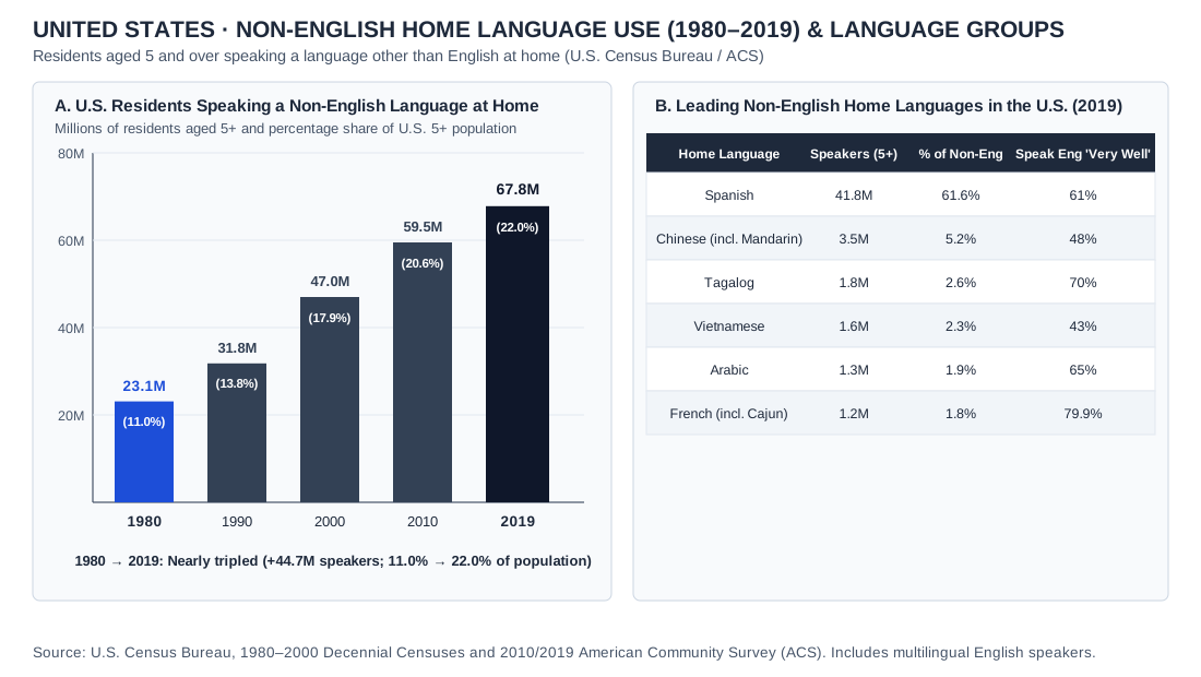
United States · non-English home-language use, 1980–2019, and leading languages
- Credit and adaptations
- Data: U.S. Census Bureau, 1980–2000 decennial censuses, 2010 and 2019 American Community Survey, and Language Use in the United States: 2019. Includes multilingual English speakers. Practice Dojo chart.
- Reuse basis
- Selected numerical facts independently re-tabulated or charted; source artwork, prose and logos not reproduced.
- Source
- Original source
- Packaged asset SHA-256
- 309432db6b2e55be72eb6b531966ee907230e3d79ca17c864291a8b6979792e4
UNIT 3 · welsh
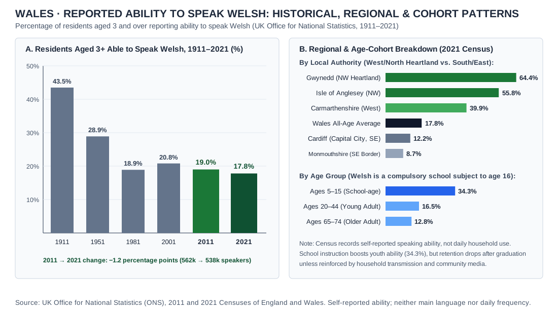
Wales · reported ability to speak Welsh: historical, regional and age patterns, 1911–2021
- Credit and adaptations
- Data: Welsh Government, Welsh language in Wales (Census 2021), December 6, 2022, and ONS 2011 and 2021 Censuses; residents aged 3 and over. Practice Dojo chart.
- Reuse basis
- Selected numerical facts independently re-tabulated or charted; source artwork, prose and logos not reproduced.
- Source
- Original source
- Packaged asset SHA-256
- 4c2c6b9dc4232e36eecb647143c0bc092d4374d2a1c5c0574c826def2b97c7e1
UNIT 3 · indo-european-branches-map
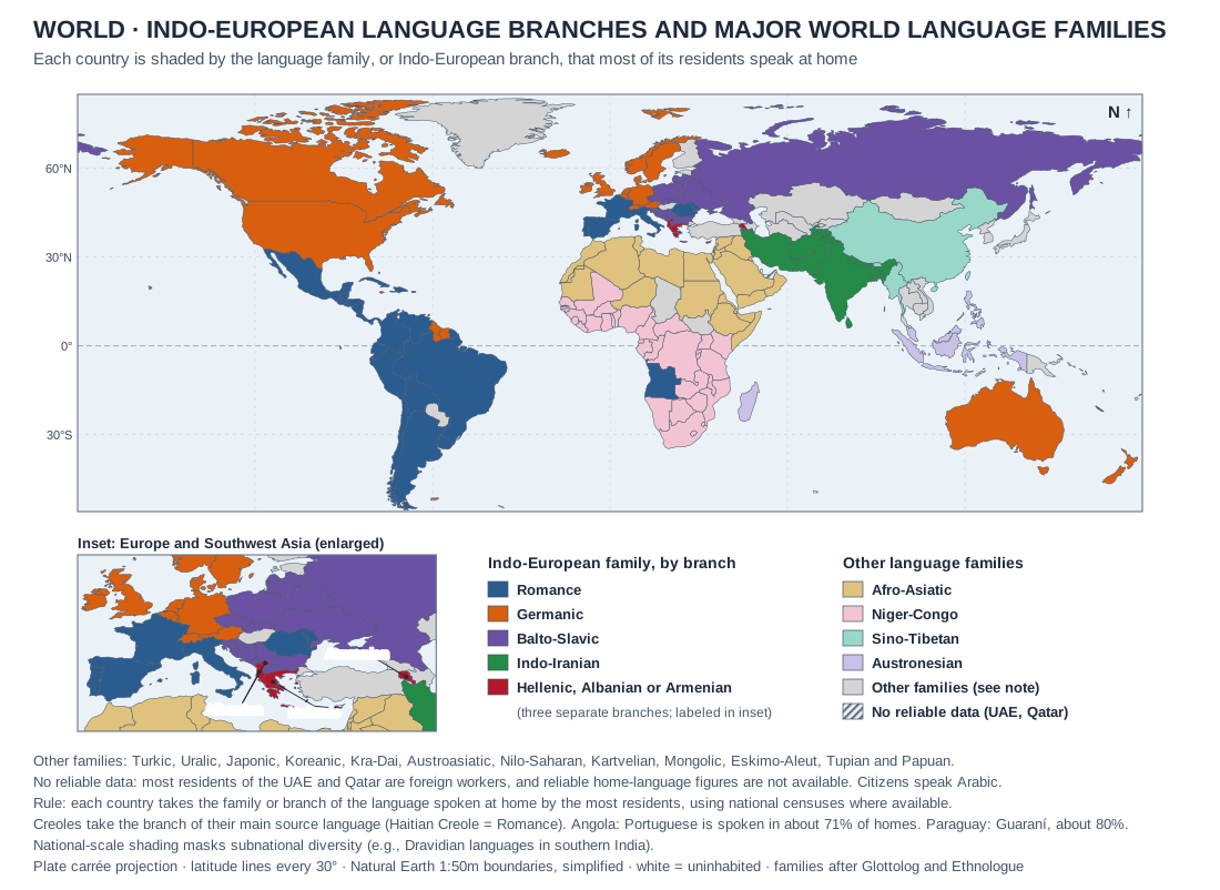
World · Indo-European language branches and major world language families
- Credit and adaptations
- Original Practice Dojo map on Natural Earth 1:50m country boundaries (simplified), with an enlarged inset of Europe and Southwest Asia. Each country is shaded by the language family, or Indo-European branch, of the language spoken at home by the most residents. Family and branch classification after Glottolog and Ethnologue. Census home-language figures were checked for borderline cases: South Africa 2022 (isiZulu 24.4%, isiXhosa 16.3%, Afrikaans 10.6%, English 8.7%), Angola 2014 (Portuguese spoken at home by about 71%) and Paraguay 2012 (Guaraní used in about 80% of homes). Creoles take the branch of their main source language. The UAE and Qatar are shown as no reliable data because most residents are foreign workers. Revision r2 corrects the earlier version, which shaded Greece, Albania and Iraq as Indo-Iranian and South Africa as Germanic, merged Afro-Asiatic with Niger-Congo, and mixed official-language and majority-language rules.
- Reuse basis
- Natural Earth public-domain geometry; standard linguistic classification and public census figures charted by Practice Dojo.
- Source
- Original source
- Packaged asset SHA-256
- 110f935945990659fe468b51cd60ca7069fbea812c05008b2a48d9dd8c5b9d1e
UNIT 3 · internet-adoption-diffusion
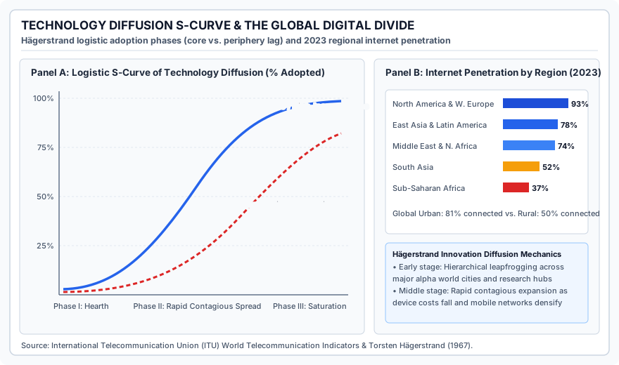
Technology diffusion S-curve and the global digital divide, 2023
- Credit and adaptations
- Practice Dojo chart. Panel A is a conceptual model after Torsten Hägerstrand (1967). Panel B: International Telecommunication Union (ITU) data for 2023, as stated in the chart; regional groupings are Practice Dojo’s.
- Reuse basis
- ITU statistical series independently charted by Practice Dojo.
- Source
- Original source
- Packaged asset SHA-256
- f724f42387a865e3f336c76e4845ed7e26913a3fa561dbf8a75b5598028c1df7
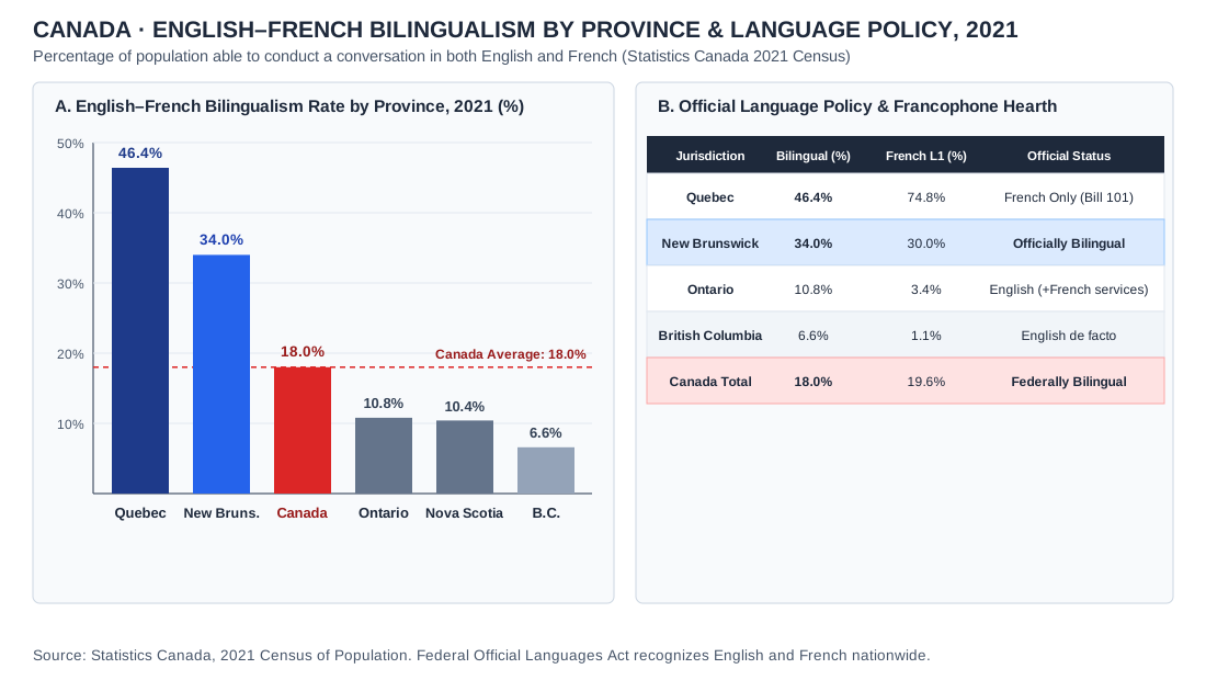
UNIT 3 · canada-bilingualism-chart
Canada · English–French bilingualism by province and language policy, 2021 Census
- Credit and adaptations
- Statistics Canada, 2021 Census of Population: Official language proficiency.
- Reuse basis
- Statistics Canada open data independently charted by Practice Dojo.
- Source
- Original source
- Packaged asset SHA-256
- bb2441c6e95d308a0fc06bd7f0f0e0789b4b3cb8c148f594caac12126992115b
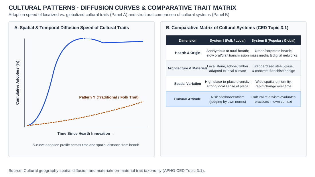
UNIT 3 · cultural-traits-matrix
Cultural patterns · Adoption speed curves and comparative cultural trait matrix · conceptual model
- Credit and adaptations
- Practice Dojo original cartographic and analytical exhibit aligned to APHG CED Topic 3.1. Cultural patterns · Adoption speed curves and comparative cultural trait matrix · conceptual model.
- Reuse basis
- Original vector diagram / Natural Earth 1:110m public-domain geometry and documented public statistical series.
- Packaged asset SHA-256
- ca369d6a98e4bd7883ba813749e267ab0dab4f981e77e73072f9f6f74141ef23
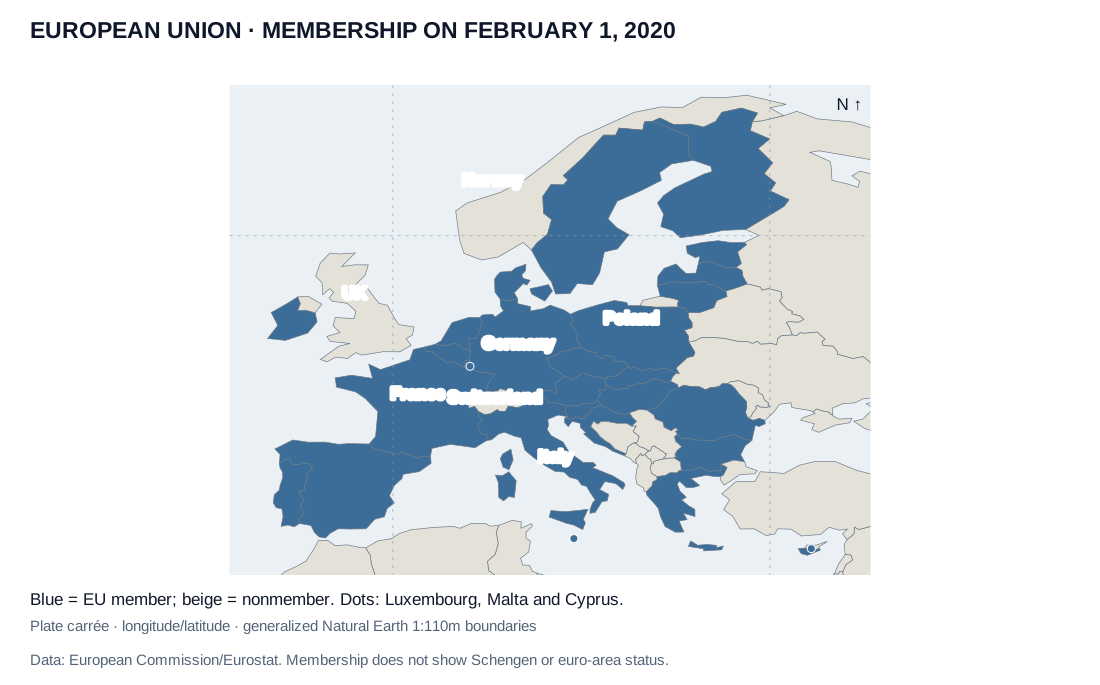
UNIT 4 · eu
European Union · membership on February 1, 2020
- Credit and adaptations
- European Commission membership history and Eurostat EU-27 definition, February 2020; Natural Earth boundaries. Original thematic map.
- Reuse basis
- Selected numerical facts independently re-tabulated or charted; source artwork, prose and logos not reproduced. Natural Earth public-domain country boundaries; original thematic rendering. Generalized de facto lines are not an endorsement of claims.
- Source
- Original source
- Packaged asset SHA-256
- c053f660b2d78c7336233726719bff7396c8c7d4a8dce2133b9f841989356de6
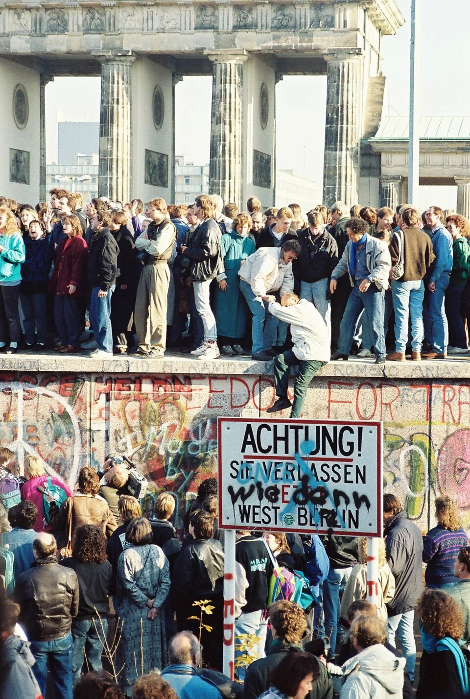
UNIT 4 · berlin
Berlin Wall near Brandenburg Gate · 1989
- Credit and adaptations
- Sue Ream, BerlinWall-BrandenburgGate.jpg, 1989, via Wikimedia Commons. Existing cropped version; resized/re-encoded, scene unchanged. Exact day disputed in the file metadata; only year used.
- Reuse basis
- CC BY 3.0; credit, source and license retained.
- Source
- Original source · License
- Packaged asset SHA-256
- 5ac79a355a6da84ac2c37e86695b0b615876ba9b5e359d6079b43ae27d01bee6
UNIT 4 · africa-borders
Sahara and Sahel · actual international boundaries
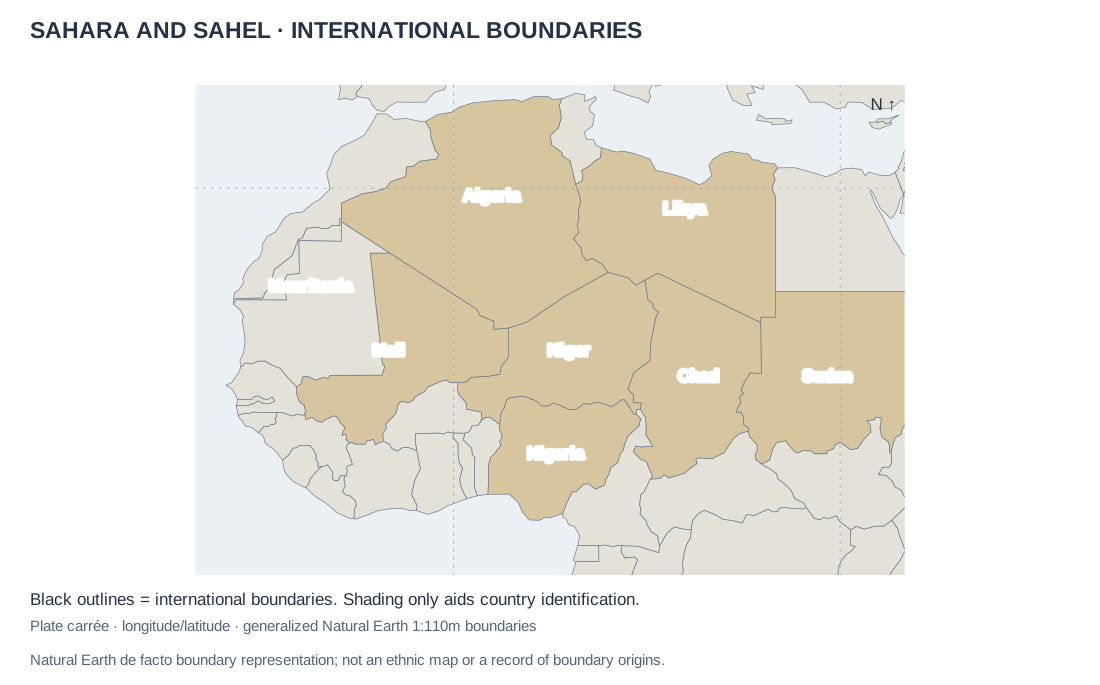
- Credit and adaptations
- Natural Earth country boundaries, dataset snapshot ca96624, accessed October 2026. Original reference map; no ethnic distributions inferred.
- Reuse basis
- Natural Earth public-domain country boundaries; original thematic rendering. Generalized de facto lines are not an endorsement of claims.
- Source
- Original source
- Packaged asset SHA-256
- 50970e2f2f8c054a3ae402e60bc3eb8b26772c4ff2450b9729ff553b336ab313
UNIT 4 · sudan
Sudan and South Sudan · after July 2011
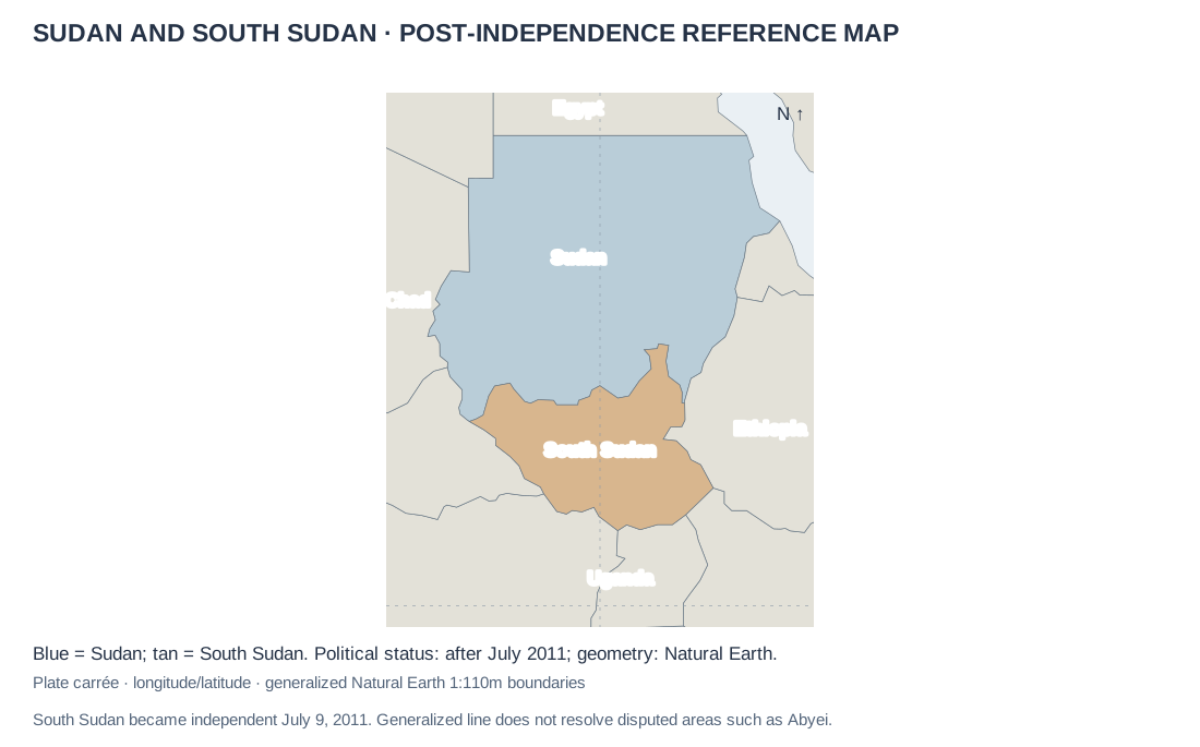
- Credit and adaptations
- United Nations historical account of South Sudan’s independence, July 9, 2011. Natural Earth generalized boundaries; original map.
- Reuse basis
- Selected numerical facts independently re-tabulated or charted; source artwork, prose and logos not reproduced. Natural Earth public-domain country boundaries; original thematic rendering. Generalized de facto lines are not an endorsement of claims.
- Source
- Original source
- Packaged asset SHA-256
- ddbaebac85a2c5dfc14e4b4943534e1558b1d9fbbfd96ac246b0aee0269885dc
UNIT 4 · seats
U.S. House apportionment · selected states, 2010 and 2020
- Credit and adaptations
- U.S. Census Bureau, 2020 Census apportionment results, April 26, 2021. Selected states and seat totals.
- Reuse basis
- Selected numerical facts independently re-tabulated or charted; source artwork, prose and logos not reproduced.
- Source
- Original source
UNIT 4 · maritime
Maritime zones · UNCLOS profile and jurisdiction rules
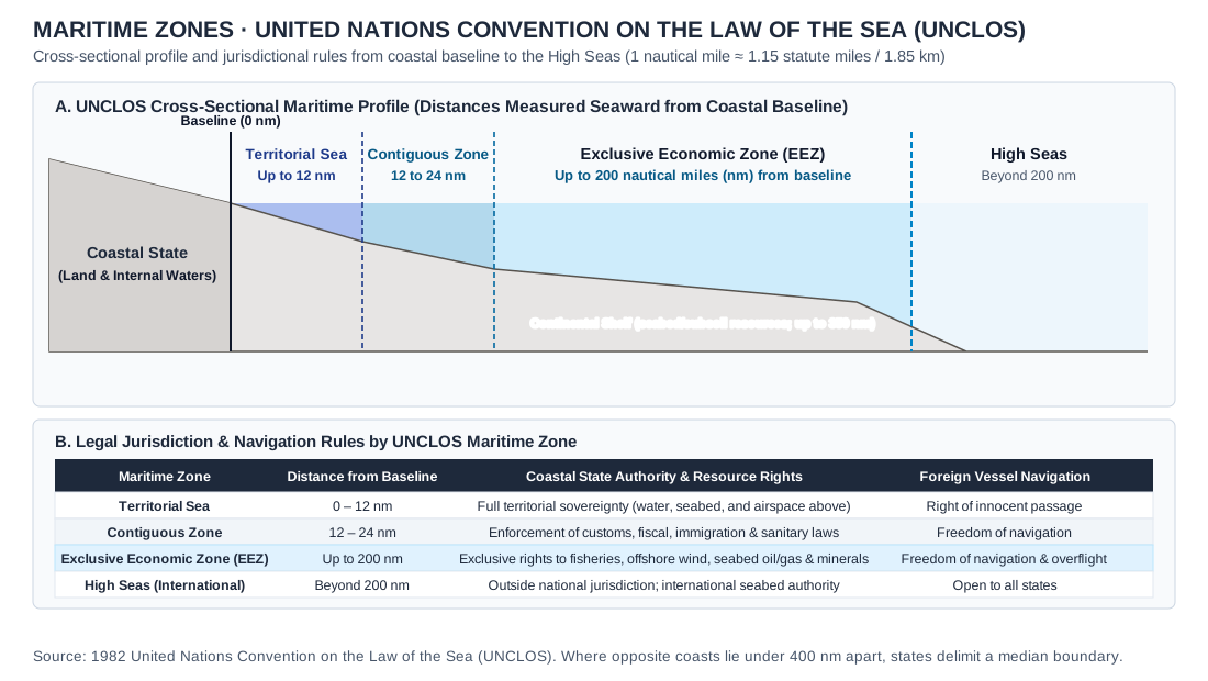
- Credit and adaptations
- Original Practice Dojo diagram based on UNCLOS (1982) Articles 3, 33, 55–58 and 76. Distances measured from a common baseline; horizontal spacing intentionally compressed.
- Reuse basis
- Original Practice Dojo drawing of a standard concept; no third-party artwork reproduced.
- Source
- Original source
- Packaged asset SHA-256
- b1f405897a450cc126f19a9c68eed403bd7feb561079f7cbd41482c3447cfc8a
UNIT 4 · uk-devolution-chart
United Kingdom · 1997–1998 devolution referendums and subnational governance
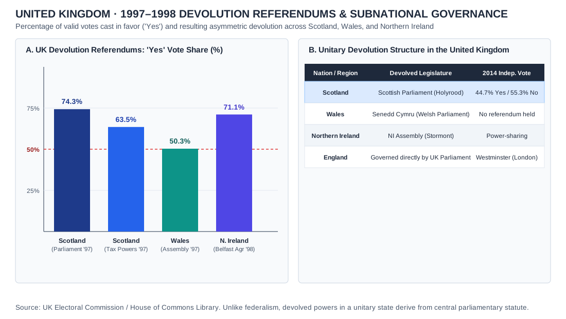
- Credit and adaptations
- Data: UK Electoral Commission and House of Commons Library briefings on the 1997 and 1998 devolution referendums and the 2014 Scottish independence referendum. Practice Dojo chart.
- Reuse basis
- Public UK parliamentary election statistics independently charted by Practice Dojo.
- Source
- Original source
- Packaged asset SHA-256
- 4b5933dbb1cea04d61fe36f73a887305f6848310f2c15b45bf01f500d812293d
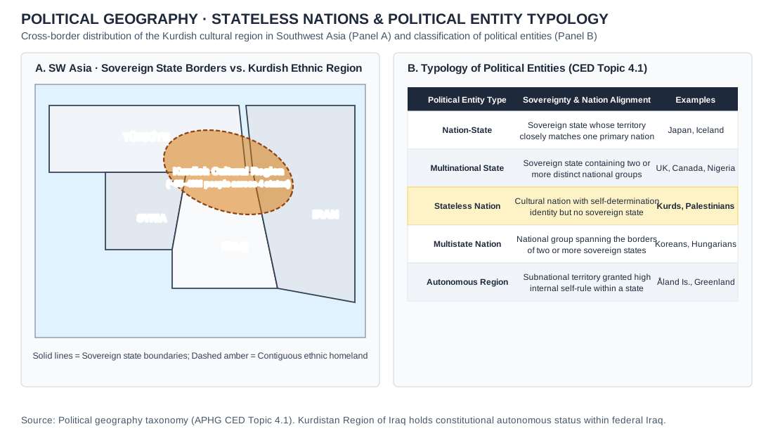
UNIT 4 · political-typology
Southwest Asia · Kurdish cultural region across four sovereign states and political entity typology
- Credit and adaptations
- Practice Dojo original cartographic and analytical exhibit aligned to APHG CED Topic 4.1. Southwest Asia · Kurdish cultural region across four sovereign states and political entity typology.
- Reuse basis
- Original vector diagram / Natural Earth 1:110m public-domain geometry and documented public statistical series.
- Packaged asset SHA-256
- 2236ccc5f7151655fdb6ef9b414c6fb9cd6d7aba40aff3d609a46e9ae5417ce8
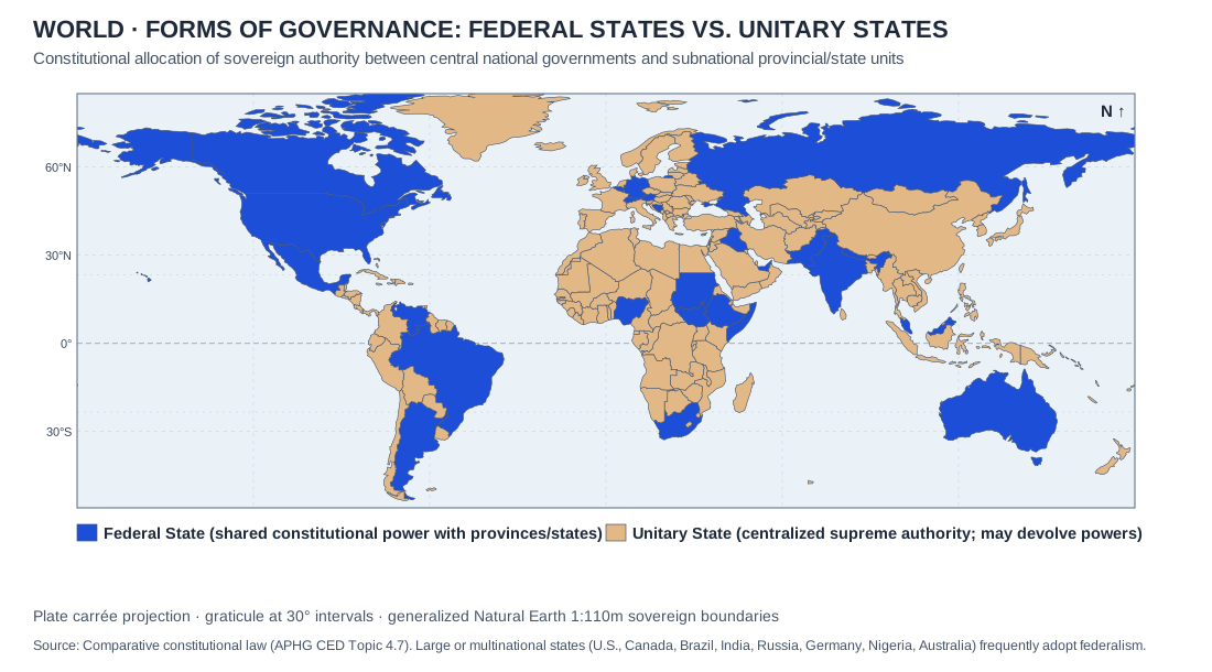
UNIT 4 · federal-unitary-map
World · Forms of governance: Federal states vs. Unitary states · comparative constitutional classification
- Credit and adaptations
- Practice Dojo original cartographic and analytical exhibit aligned to APHG CED Topic 4.7. World · Forms of governance: Federal states vs. Unitary states · comparative constitutional classification.
- Reuse basis
- Original vector diagram / Natural Earth 1:110m public-domain geometry and documented public statistical series.
- Packaged asset SHA-256
- a0ae4d9ca34136f3482399db09ec5e0de32d94f7e28bfabff92db1004e1f4660
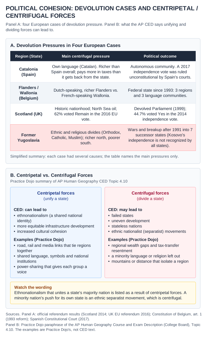
UNIT 4 · centripetal-centrifugal
Political cohesion · Four European devolution cases and a Practice Dojo summary of centripetal vs. centrifugal forces (CED Topic 4.10)
- Credit and adaptations
- Practice Dojo summary exhibit (a table and diagram, not a map), revised. Panel A facts: Scotland's 2014 independence referendum (44.7% Yes) and the 2016 UK EU referendum (62% Remain in Scotland), official results; Scottish Parliament established by the Scotland Act 1998 and first sitting in 1999; Constitution of Belgium, article 1 ("Belgium is a federal State composed of Communities and Regions"), from the 1993 state reform; the 2017 Catalan independence referendum ruled unconstitutional by Spain's Constitutional Court; Yugoslavia's breakup after 1991 into seven successor states, counting Kosovo, whose 2008 declaration of independence is not recognized by all states. Panel A is simplified and names main pressures only. Panel B paraphrases AP Human Geography Course and Exam Description (College Board) Topic 4.10: centripetal forces can lead to ethnonationalism, more equitable infrastructure development and increased cultural cohesion; centrifugal forces may lead to failed states, uneven development, stateless nations and ethnic nationalist (separatist) movements. The listed examples of each force are Practice Dojo's, not CED text. Revision r2 corrects the earlier version, which listed ethnonationalism as a centrifugal force and presented a Practice Dojo typology as CED content.
- Reuse basis
- Original Practice Dojo vector diagram; no map geometry. Facts from public official records; CED content paraphrased, not reproduced.
- Packaged asset SHA-256
- 8013aa5095f7cc0ec4b36f6d6e2c23cb7a6796bf0fcfbc0734fb4eb676dbfee9
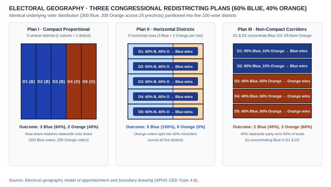
UNIT 4 · packing-cracking-redistricting-map
Spatial redistricting comparison across one 25-precinct state (300 Blue and 200 Orange voters in five 100-voter districts): Plan I (compact proportional, 3–2), Plan II (horizontal districts that crack Orange, 5–0) and Plan III (packing Blue, 2–3).
- Credit and adaptations
- Practice Dojo original cartographic and analytical exhibit aligned to APHG CED Topic 4.6. Spatial redistricting comparison across an identical 25-precinct state (60% Blue, 40% Orange): Plan A (compact proportional, 3–2), Plan B (cracking, 5–0), and Plan C (packing and cracking, 2–3).
- Reuse basis
- Original vector diagram / Natural Earth 1:110m public-domain geometry and documented public statistical series.
- Packaged asset SHA-256
- 27162b3e627df79b3a941f6f0f69bba8f283d114066dcadcd33d55185dad0585
UNIT 5 · kansas
Southwestern Kansas · ASTER, June 24, 2001
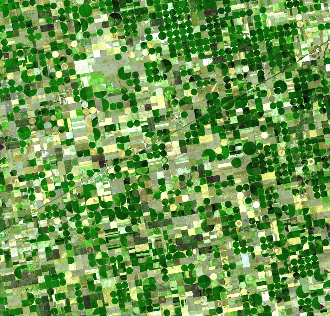
- Credit and adaptations
- NASA/GSFC/METI/ERSDAC/JAROS and U.S./Japan ASTER Science Team, via NASA Earth Observatory. Acquired June 24, 2001. Resized and encoded as WebP; scene content unchanged.
- Reuse basis
- NASA Earth Science reuse guidance; no contrary item copyright notice found. Full joint credit retained; resized only.
- Source
- Original source
- Packaged asset SHA-256
- b3fd108267c5e29c21aa61e134bdbb4cf5bd593b98e7dbfeb6b85305e14638c4
UNIT 5 · iowa
Montgomery County, Iowa · contour-aligned cultivation
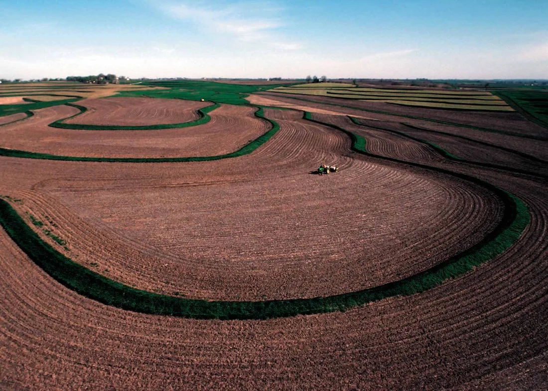
- Credit and adaptations
- Photo by Lynn Betts, USDA Natural Resources Conservation Service, NRCSIA99373. Public domain U.S. federal work. Resized and encoded as WebP; scene content unchanged. Original capture date not independently established.
- Reuse basis
- Public-domain U.S. federal work; source credit retained. Resized/re-encoded; scene unchanged.
- Source
- Original source
- Packaged asset SHA-256
- bafa42b1f10dbf3dfa8f23393ddcb5a53beaf1f271c929c5ba9094b60d0a03bc
UNIT 5 · banaue
Banaue, Philippines · terraced agricultural landscape, 2011
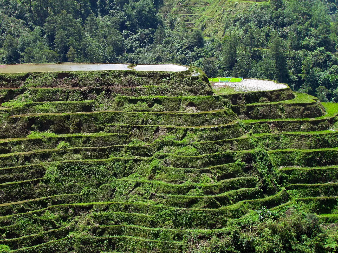
- Credit and adaptations
- Jose B. Cabajar (Cabajar), Banaue RiceTerraces.jpg, April 13, 2011, via Wikimedia Commons. Resized/re-encoded; scene unchanged.
- Reuse basis
- CC BY-SA 3.0; photograph remains under its stated license.
- Source
- Original source · License
- Packaged asset SHA-256
- a79a23605c682fdab4ac33d2d3161ae42a9673da8fbcf6ab7028dc03e866e027
UNIT 5 · amazon
Brazil · contrasting deforestation patterns, 2019 montage
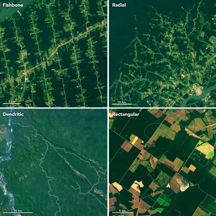
- Credit and adaptations
- NASA Earth Observatory images by Lauren Dauphin, Landsat/USGS and MODIS/NASA data. Published November 22, 2019; original montage retained, resized/re-encoded.
- Reuse basis
- NASA Earth Science reuse guidance; no contrary item copyright notice found; full credit retained.
- Source
- Original source
- Packaged asset SHA-256
- c896d2c93537ab04863bd5ebb76b0d8a875f20f9c1940aca93f6b7bd68655877
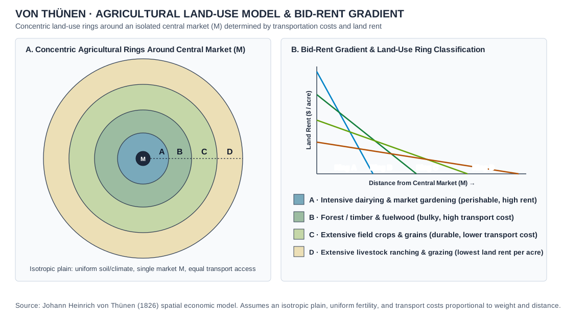
UNIT 5 · von-thunen
Von Thünen · agricultural land-use model and bid-rent gradient
- Credit and adaptations
- Original Practice Dojo drawing of Johann Heinrich von Thünen’s (1826) four-ring model and bid-rent gradient. Assumes an isotropic plain, uniform fertility and transport costs proportional to weight and distance. Not observed agricultural data.
- Reuse basis
- Original Practice Dojo drawing of a standard concept; no third-party artwork reproduced.
- Source
- Original source
- Packaged asset SHA-256
- a31692a4b87d032c3bd67c8733e7c9809fec1654e3eb5632fbeb53cc06e83873
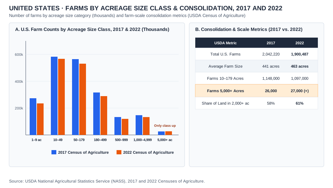
UNIT 5 · farms
United States · farms by acreage class and consolidation, 2017 and 2022
- Credit and adaptations
- Data: USDA NASS, 2017 and 2022 Censuses of Agriculture; 2022 Census of Agriculture Highlights, Farms and Farmland, March 2024. Counts in thousands of farms, rounded. Practice Dojo chart.
- Reuse basis
- Selected numerical facts independently re-tabulated or charted; source artwork, prose and logos not reproduced.
- Source
- Original source
- Packaged asset SHA-256
- 4be51c32f84de57b19c8a4e77eabfc690f2e2815f171e28de4dd20c49a0b7128
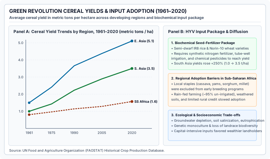
UNIT 5 · green-revolution-yields
Green Revolution · cereal yields by region and the input package, 1961–2020
- Credit and adaptations
- Data: UN Food and Agriculture Organization (FAOSTAT), cereal yield in metric tons per hectare, as stated in the chart. Practice Dojo chart.
- Reuse basis
- FAO/World Bank statistical series independently charted by Practice Dojo.
- Source
- Original source
- Packaged asset SHA-256
- 303e75852985c994cf9442d488abfbb5e9988da3bbd158113066dfe83ba7cc4b
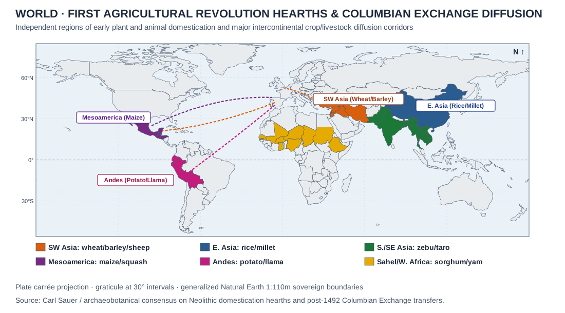
UNIT 5 · agricultural-hearths-map
First Agricultural Revolution hearths and Columbian Exchange diffusion · representative modern countries
- Credit and adaptations
- Original Practice Dojo map on Natural Earth 1:110m boundaries showing representative modern countries in six early domestication hearths and post-1492 Columbian Exchange transfers. Based on Carl Sauer and the archaeobotanical consensus.
- Reuse basis
- Natural Earth public-domain geometry; charted by Practice Dojo.
- Source
- Original source
- Packaged asset SHA-256
- 646bbeef4b821cb363ba49ecb770ce00437ae67fb464810f940401d3d11980ff
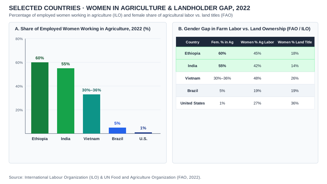
UNIT 5 · female-ag-employment-chart
Selected countries · women in agriculture and the landholder gap, 2022
- Credit and adaptations
- Data: International Labour Organization (ILO) and UN Food and Agriculture Organization (FAO), 2022, as stated in the chart. Practice Dojo chart.
- Reuse basis
- ILO and FAO statistical data independently charted by Practice Dojo.
- Source
- Original source
- Packaged asset SHA-256
- 659b378b8ecaec9394ec3cd8cd50e9eca6f82d960917d1871504be7398610939
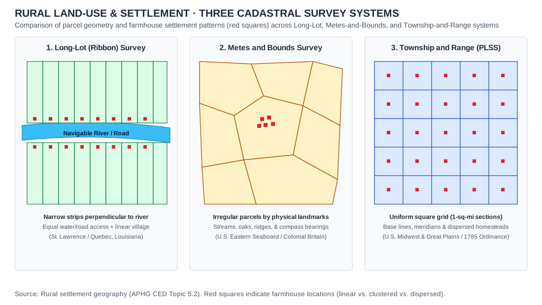
UNIT 5 · rural-survey-systems
Rural land-use and settlement · Long-Lot, Metes-and-Bounds, and Township-and-Range survey systems
- Credit and adaptations
- Practice Dojo original cartographic and analytical exhibit aligned to APHG CED Topic 5.2. Rural land-use and settlement · Long-Lot, Metes-and-Bounds, and Township-and-Range survey systems.
- Reuse basis
- Original vector diagram / Natural Earth 1:110m public-domain geometry and documented public statistical series.
- Packaged asset SHA-256
- aafc689b2da4f8cd7e43d176fd18a9bc83c14a7b5c566975a4dd55f03c611080
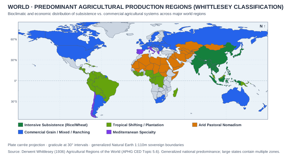
UNIT 5 · whittlesey-regions
World · Predominant agricultural production regions (Whittlesey classification) · conceptual/bioclimatic map
- Credit and adaptations
- Practice Dojo original cartographic and analytical exhibit aligned to APHG CED Topic 5.6. World · Predominant agricultural production regions (Whittlesey classification) · conceptual/bioclimatic map.
- Reuse basis
- Original vector diagram / Natural Earth 1:110m public-domain geometry and documented public statistical series.
- Packaged asset SHA-256
- d7031612ad1bafb5f813ceb839bee8d5638bcdce72dc612209b1b5a0dad0a926
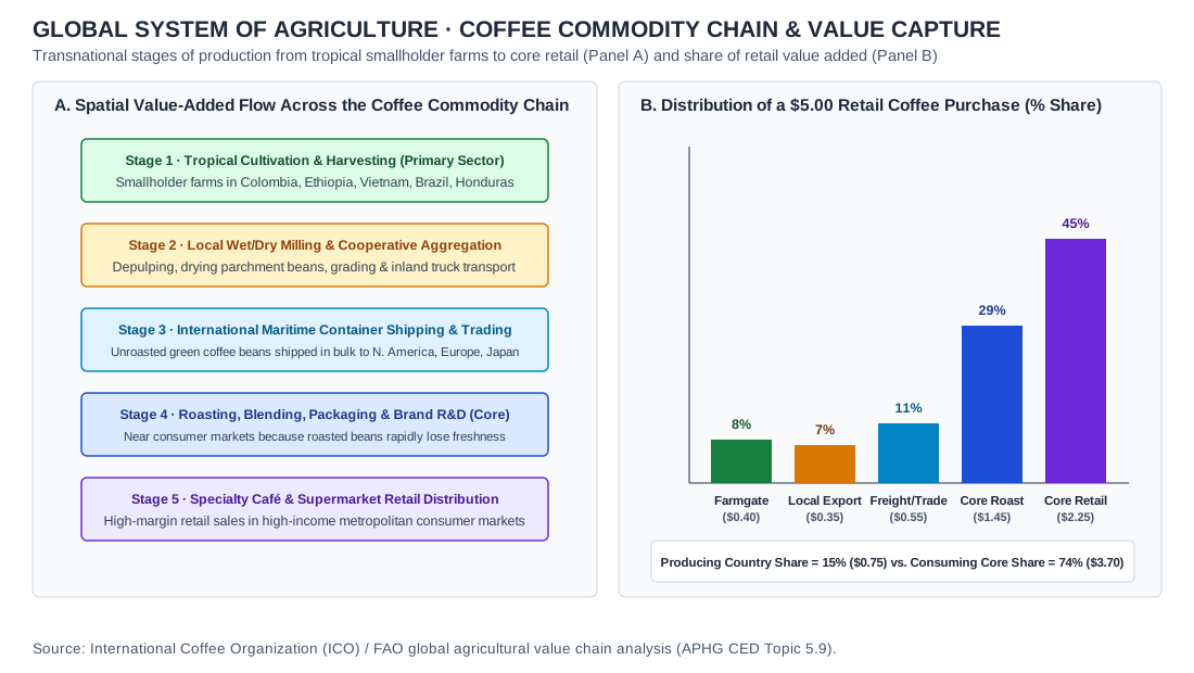
UNIT 5 · global-agribusiness-commodity-chain
Global coffee commodity chain across five stages (Panel A) and the distribution of a $5.00 retail purchase: 8% ($0.40) at the farm gate and 15% ($0.75) in producing countries, compared with 74% ($3.70) captured by roasting and retail in consuming core countries (Panel B).
- Credit and adaptations
- Practice Dojo original analytical exhibit aligned to APHG CED Topic 5.9, based on International Coffee Organization and FAO value-chain analysis as stated in the chart. Global coffee commodity chain across five stages (Panel A) and the distribution of a $5.00 retail purchase: 8% ($0.40) at the farm gate and 15% ($0.75) in producing countries, compared with 74% ($3.70) captured by roasting and retail in consuming core countries (Panel B).
- Reuse basis
- Original vector diagram / Natural Earth 1:110m public-domain geometry and documented public statistical series.
- Packaged asset SHA-256
- 5efb1c09668600a16dbbf3faf298764fb43f7159535ddd62e2f5b0adb00eefa7
UNIT 6 · delhi
NCT Delhi · census totals and a local transport scene
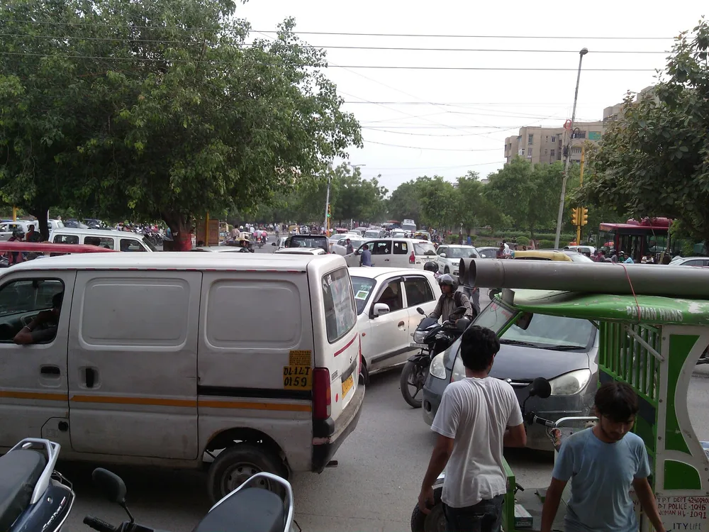
- Credit and adaptations
- Table: Census of India totals reproduced in Government of NCT of Delhi, Economic Survey 2025–26, Statement 19.9. Photograph: Rrthakur22, Deltraffic3, August 4, 2018, CC BY-SA 4.0, via Wikimedia Commons. Resized and encoded as WebP; scene content unchanged. The local 2018 scene is not a time series of the entire NCT.
- Reuse basis
- Photo: CC BY-SA 4.0, retained for the resized photograph. Table: independently re-tabulated numerical facts with government source credit.
- Source
- Original source · Data source · Photo license
- Packaged asset SHA-256
- 819c0ef60b9cf5ded78b5fa1525dac586244487de8f9588d0ddb8e6518521bb2
UNIT 6 · kibera
Kibera, Nairobi · rooftops and streets, 2007
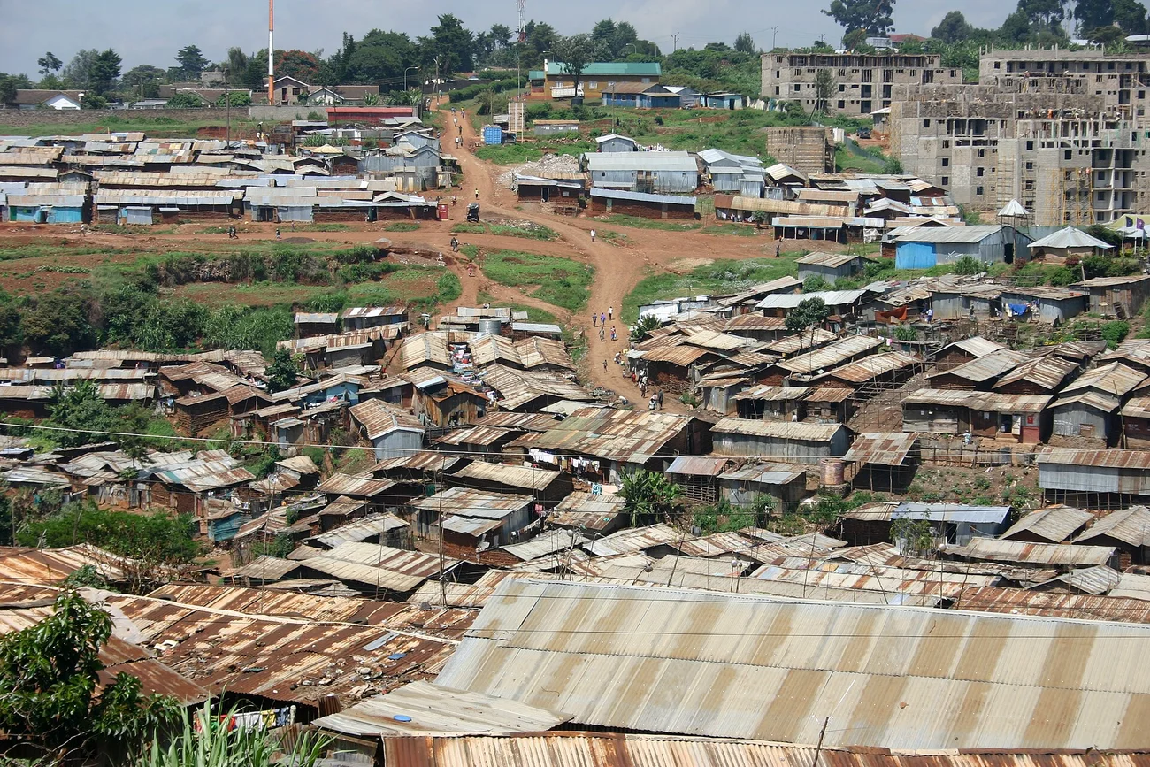
- Credit and adaptations
- Genvessel, Kibera rooftops and streets, May 21, 2007, via Wikimedia Commons/Flickr. Resized/re-encoded; scene unchanged.
- Reuse basis
- CC BY 2.0; credit, source and license retained.
- Source
- Original source · License
- Packaged asset SHA-256
- db07cffe7aa59b831bf7e427652767e08f829d62148e45423948ad1c8107a40d
UNIT 6 · urban-models
Urban land use · three classic North American models
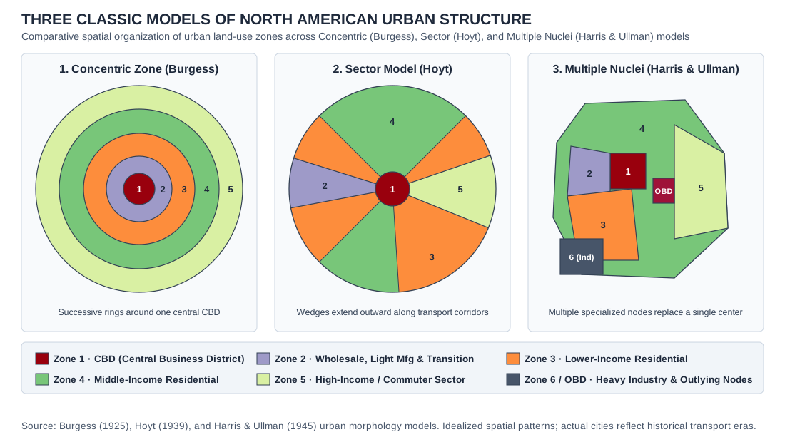
- Credit and adaptations
- Original Practice Dojo comparative drawings of Burgess, Hoyt, and Harris–Ullman concepts; not traced from published figures.
- Reuse basis
- Original Practice Dojo drawing of a standard concept; no third-party artwork reproduced.
- Source
- Original source
- Packaged asset SHA-256
- e7516bfbe280233a358d9641eca0cf0dae0b57be92b9a78e89a9570448a31f8f
UNIT 6 · latin-model
Latin American city · Griffin–Ford structural model
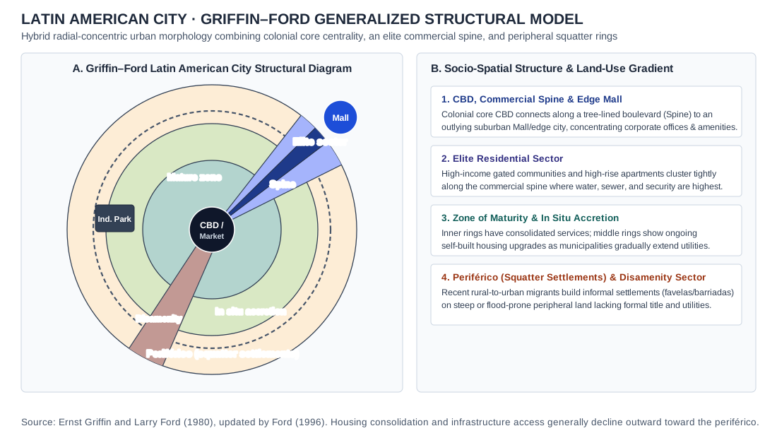
- Credit and adaptations
- Original Practice Dojo interpretation of the Griffin–Ford model tradition, with commercial spine, elite sector, maturity/accretion/peripheral zones, mall and disamenity corridor.
- Reuse basis
- Original Practice Dojo drawing of a standard concept; no third-party artwork reproduced.
- Source
- Original source
- Packaged asset SHA-256
- afa66d0abb66bea6fa0dcf5abc1d755df55aec26ad26334e7c5618ca3b0b5886
UNIT 6 · city-rank
Largest U.S. cities · 2020 municipal populations
- Credit and adaptations
- U.S. Census Bureau, 2020 Census, Facts by Decade. City-proper populations within municipal boundaries, not metropolitan areas.
- Reuse basis
- Selected numerical facts independently re-tabulated or charted; source artwork, prose and logos not reproduced.
- Source
- Original source
UNIT 6 · vegas
Las Vegas · Landsat urban growth, 1984–2009
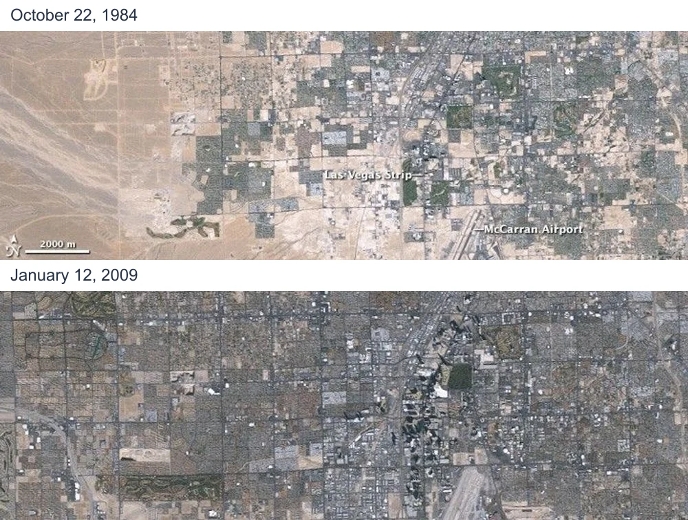
- Credit and adaptations
- NASA images by Jesse Allen and Robert Simmon, using Landsat 5/USGS data. October 22, 1984 and January 12, 2009 panels paired with date labels; source scenes unchanged.
- Reuse basis
- NASA Earth Science reuse guidance; no contrary item copyright notice found. Resized and paired; date labels added.
- Source
- Original source
- Packaged asset SHA-256
- f4c24ca181f1defa249b8ee3bf1583fd10eb26880ee18dc2d615baccf9ad8480
UNIT 6 · us-commute-modes-chart
United States · commute mode shares by metropolitan area, 2022
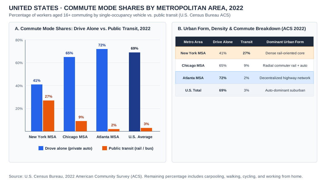
- Credit and adaptations
- U.S. Census Bureau, 2022 American Community Survey (ACS) 1-Year Estimates, Table S0801.
- Reuse basis
- Public-domain U.S. Census ACS statistics independently charted by Practice Dojo.
- Source
- Original source
- Packaged asset SHA-256
- 6997351c113d3a7cb989344e3073b1ca598cb9c106fc67de413b56e88d9deb32
UNIT 6 · megacities-map
World · megacities (10M+ agglomerations) and host countries, 2023
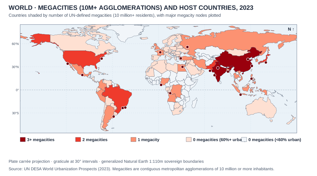
- Credit and adaptations
- UN DESA World Urbanization Prospects on Natural Earth 1:110m boundaries.
- Reuse basis
- Natural Earth public-domain geometry; UN urban agglomeration counts charted by Practice Dojo.
- Source
- Original source
- Packaged asset SHA-256
- 479012555fce003b74e52e21c1f3ce51d11fffeb3b3802d0331eabe581ab7117
UNIT 6 · urban-hearths-site
Urbanization origins · Formative ancient urban hearths and site vs. situation factors
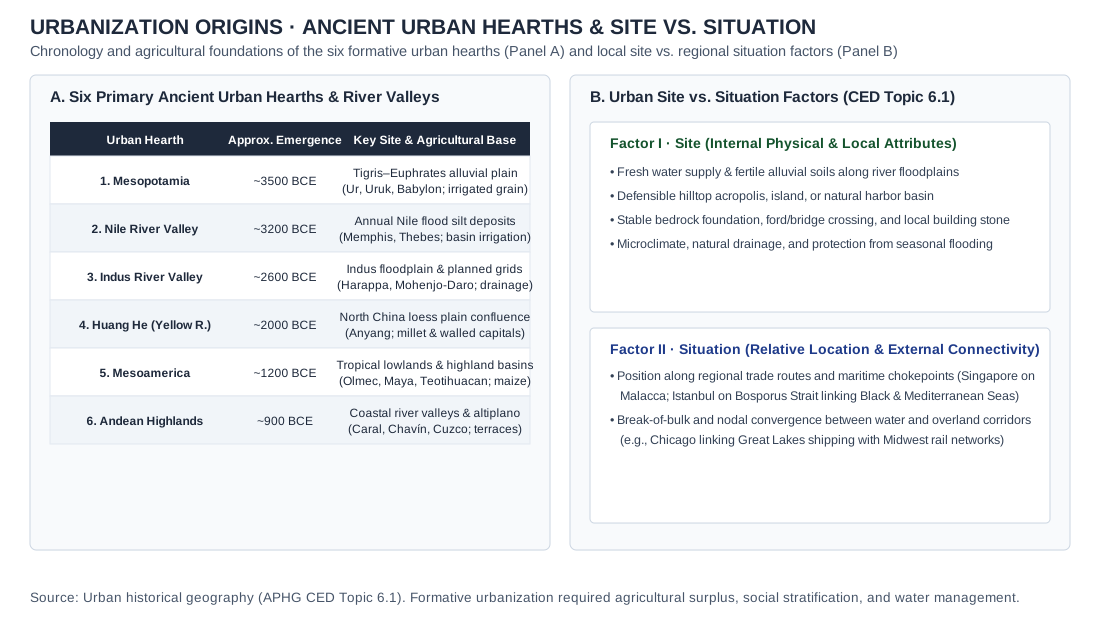
- Credit and adaptations
- Practice Dojo original cartographic and analytical exhibit aligned to APHG CED Topic 6.1. Urbanization origins · Formative ancient urban hearths and site vs. situation factors.
- Reuse basis
- Original vector diagram / Natural Earth 1:110m public-domain geometry and documented public statistical series.
- Packaged asset SHA-256
- 07d2af6197907ddbd3a7fcb75e5eb876c0f38e83e502ef472ee3a1787164c342
UNIT 6 · urban-bid-rent
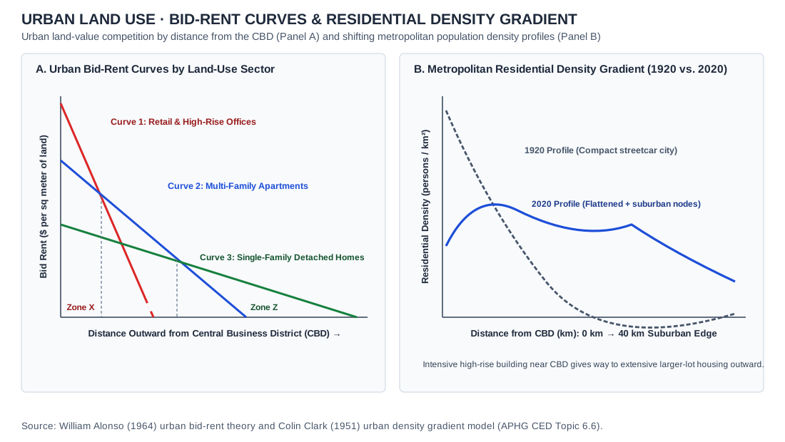
Urban land use · Alonso bid-rent curves and Clark metropolitan residential density gradients
- Credit and adaptations
- Practice Dojo original cartographic and analytical exhibit aligned to APHG CED Topic 6.6. Urban land use · Alonso bid-rent curves and Clark metropolitan residential density gradients.
- Reuse basis
- Original vector diagram / Natural Earth 1:110m public-domain geometry and documented public statistical series.
- Packaged asset SHA-256
- 36abb6e99b2b9337a02a181a98b51a333474294d439bdc6db90390237a751eb3
UNIT 6 · census-tract-data
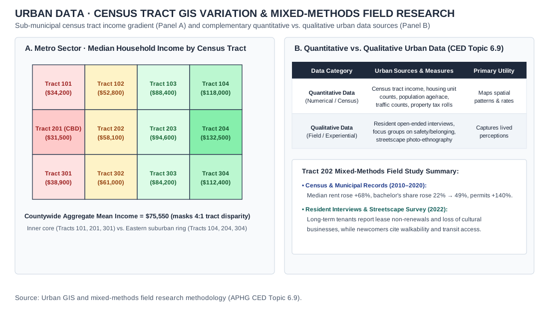
Urban data · Sub-municipal census tract GIS income gradient and mixed-methods field research
- Credit and adaptations
- Practice Dojo original cartographic and analytical exhibit aligned to APHG CED Topic 6.9. Urban data · Sub-municipal census tract GIS income gradient and mixed-methods field research.
- Reuse basis
- Original vector diagram / Natural Earth 1:110m public-domain geometry and documented public statistical series.
- Packaged asset SHA-256
- c5cc8803453e6c8115e80191069b7bbadf9fd5af2cc0f3cf56f618a013f91d02
UNIT 6 · galactic-peripheral-city-model
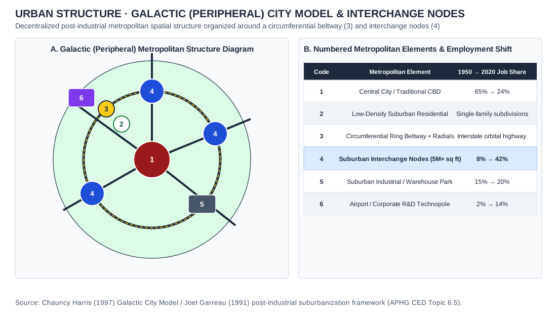
Chauncy Harris's Galactic (Peripheral) City Model showing numbered functional zones (1 CBD, 2 Suburban Residential, 3 Orbital Beltway, 4 Edge Cities, 5 Industrial Park, 6 Airport Corridor) and spatial decentralization mechanics
- Credit and adaptations
- Practice Dojo original cartographic and analytical exhibit aligned to APHG CED Topic 6.5. Chauncy Harris's Galactic (Peripheral) City Model showing numbered functional zones (1 CBD, 2 Suburban Residential, 3 Orbital Beltway, 4 Edge Cities, 5 Industrial Park, 6 Airport Corridor) and spatial decentralization mechanics.
- Reuse basis
- Original vector diagram / Natural Earth 1:110m public-domain geometry and documented public statistical series.
- Packaged asset SHA-256
- db20c31aba4ffa0689fe651c735fa7d2ebc00a6a3f6bdd466e771da30ceda12c
UNIT 6 · new-urbanism-transit-oriented-design
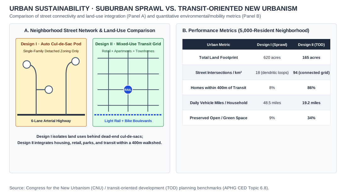
Suburban sprawl (Design I) and transit-oriented New Urbanism (Design II): street networks and land use (Panel A) and performance metrics for a 5,000-resident neighborhood (Panel B).
- Credit and adaptations
- Practice Dojo original cartographic and analytical exhibit aligned to APHG CED Topic 6.8. Comparison of suburban sprawl (Design I) and transit-oriented New Urbanism (Design II), with street networks in Panel A and performance metrics in Panel B.
- Reuse basis
- Original vector diagram / Natural Earth 1:110m public-domain geometry and documented public statistical series.
- Packaged asset SHA-256
- 1b4d86e1bdb9d160627958ed0ab3f4f32f7bcb355faefba463ac8639be176a5a
UNIT 7 · coal
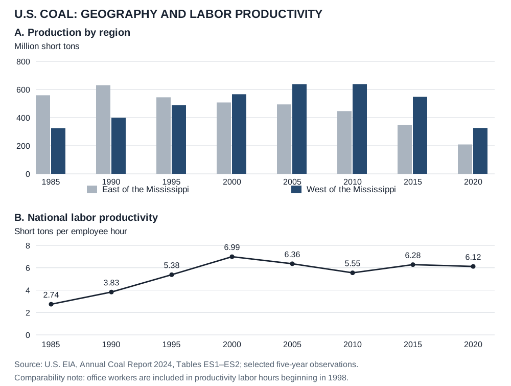
U.S. coal · production geography and labor productivity
- Credit and adaptations
- Practice Dojo chart from U.S. EIA, Annual Coal Report 2024 (November 2025), Tables ES1 and ES2. Five-year observations selected; production converted to million short tons and rounded to one decimal. EIA changed the labor-hour definition in 1998 to include office workers; this comparability note is retained below the chart.
- Reuse basis
- EIA public-domain numerical data; original Practice Dojo chart. EIA reuse guidance permits distribution with acknowledgment.
- Source
- Original source · ES1 production · ES2 productivity · Reuse terms
- Packaged asset SHA-256
- 07bc7bc43f5b7aebc17281381c4223be505fa925b22185e96c20947abcebf39f
UNIT 7 · nellis
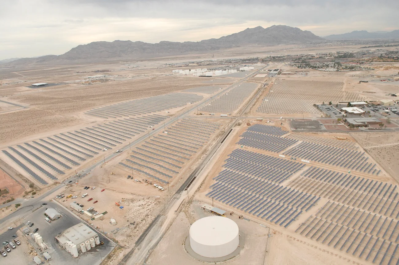
Nellis, Nevada · ground-mounted solar array, 2007
- Credit and adaptations
- Master Sgt. Robert Valenca / U.S. Air Force, November 9, 2007. Via Wikimedia Commons. Resized/re-encoded; scene unchanged.
- Reuse basis
- Public-domain U.S. federal work; source credit retained. Resized/re-encoded; scene unchanged.
- Source
- Original source
- Packaged asset SHA-256
- 44f400e54580396627adb952639e7478c313c404eb70141c87c567cba0433b30
UNIT 7 · hdi
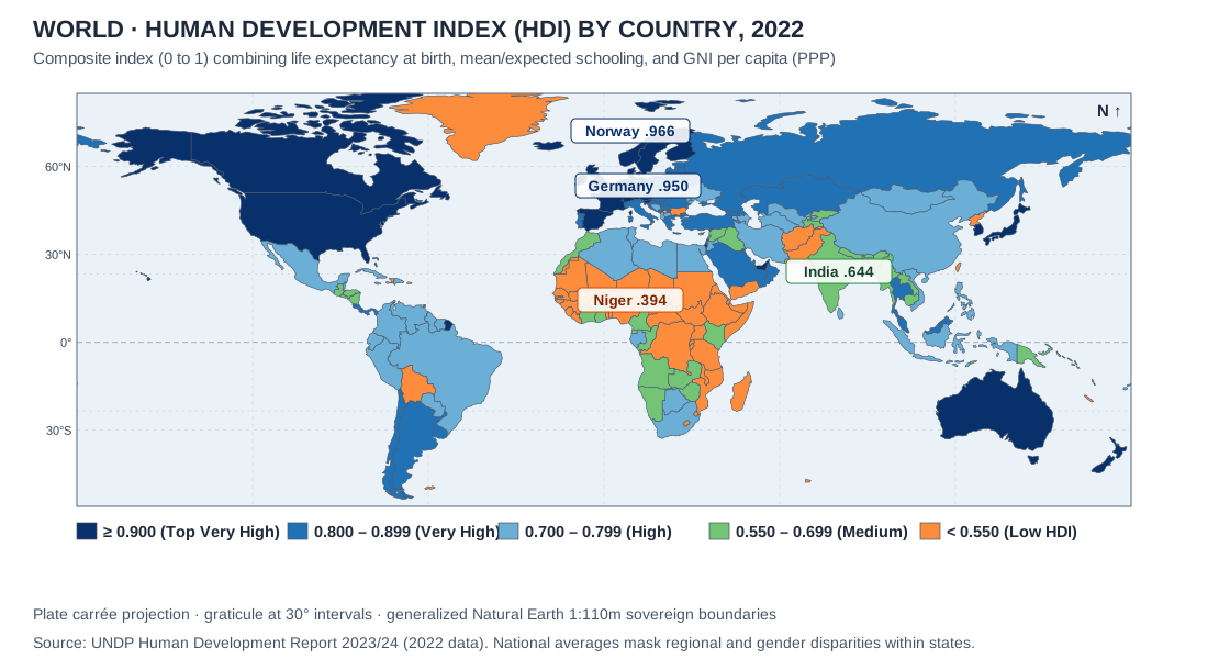
World · Human Development Index by country, 2022
- Credit and adaptations
- UNDP Human Development Report 2023/24, 2022 HDI values, as stated in the map. Original Practice Dojo map on Natural Earth boundaries.
- Reuse basis
- Selected numerical facts independently re-tabulated or charted; source artwork, prose and logos not reproduced. Natural Earth public-domain country boundaries; original thematic rendering. Generalized de facto lines are not an endorsement of claims.
- Source
- Original source
- Packaged asset SHA-256
- 9a2a0fb39db0786284663dbcda8f5674fdcab7ee7b7f7e5402ec973ea97ac8a2
UNIT 7 · trade
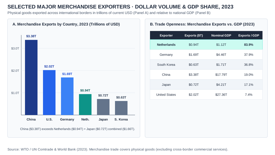
Selected major merchandise exporters · export value and share of GDP, 2023
- Credit and adaptations
- Practice Dojo chart using WTO / UN Comtrade merchandise export data and World Bank nominal GDP for 2023, as stated in the chart. Six selected countries.
- Reuse basis
- Selected numerical facts independently re-tabulated or charted; source artwork, prose and logos not reproduced.
- Source
- Original source
- Packaged asset SHA-256
- 82c1ff9f83fb60930266e22bc070efe24951170e382761535e23720599aa992e
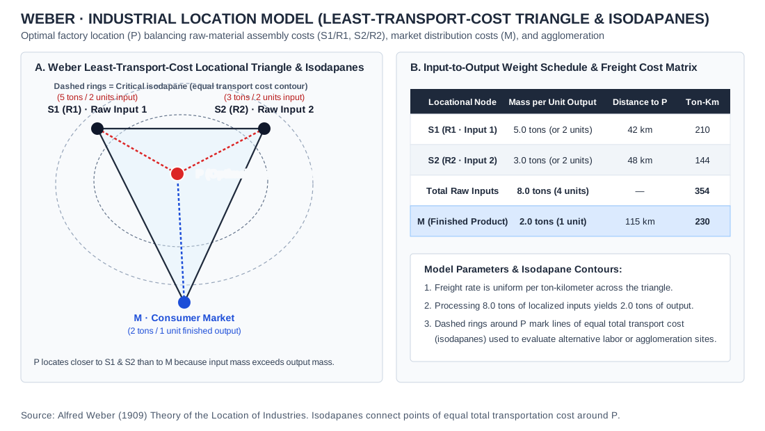
UNIT 7 · weber
Weber · least-transport-cost triangle and isodapanes
- Credit and adaptations
- Original Practice Dojo drawing of Alfred Weber’s (1909) least-transport-cost model. Two units from each input (8.0 tons in all) become one unit of output (2.0 tons); uniform freight rate per ton-kilometer; other location forces held equal.
- Reuse basis
- Original Practice Dojo drawing of a standard concept; no third-party artwork reproduced.
- Source
- Original source
- Packaged asset SHA-256
- c52be7a3acf3083d34b0194cc0b7fdc1be5766e57a6a0bf3843c807fadd6c240
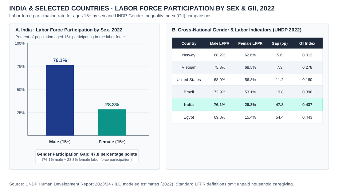
UNIT 7 · gender
India and selected countries · labor force participation by sex and the Gender Inequality Index, 2022
- Credit and adaptations
- Data: UNDP Human Development Report 2023/24 and ILO modeled estimates for 2022, as stated in the chart. India: women 28.3%, men 76.1%, ages 15+. Practice Dojo chart.
- Reuse basis
- Selected numerical facts independently re-tabulated or charted; source artwork, prose and logos not reproduced.
- Source
- Original source
- Packaged asset SHA-256
- bb27a9e9670ef0afcb876202c134d417ab1f647248ba8038a600d4ff590f1e9b
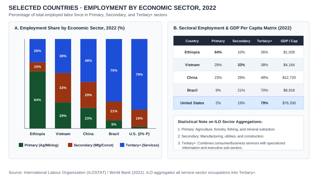
UNIT 7 · sector-employment-chart
Selected countries · employment by economic sector, 2022
- Credit and adaptations
- Data: International Labour Organization (ILOSTAT) and World Bank (2022), as stated in the chart. Practice Dojo chart.
- Reuse basis
- ILO/World Bank statistical data independently charted by Practice Dojo.
- Source
- Original source
- Packaged asset SHA-256
- a4a4d1710a1781f1d7b7f24d59a2cf3e7562c93e0ab0758866799807dae4009f
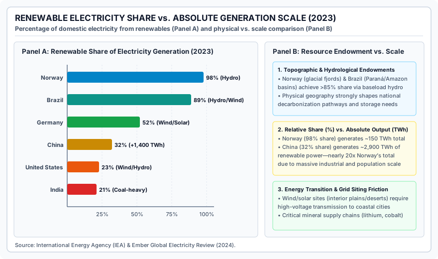
UNIT 7 · renewable-electricity-chart
Renewable share of electricity generation in six countries, 2023
- Credit and adaptations
- Practice Dojo chart using data from the International Energy Agency (IEA) and Ember, Global Electricity Review (2024), as stated in the chart.
- Reuse basis
- Public-domain U.S. federal data independently charted by Practice Dojo.
- Source
- Original source
- Packaged asset SHA-256
- 28924b721987c8a5a4549fb7852abcbf1aebe2684de0f1be0be1ba7d0e6c211a
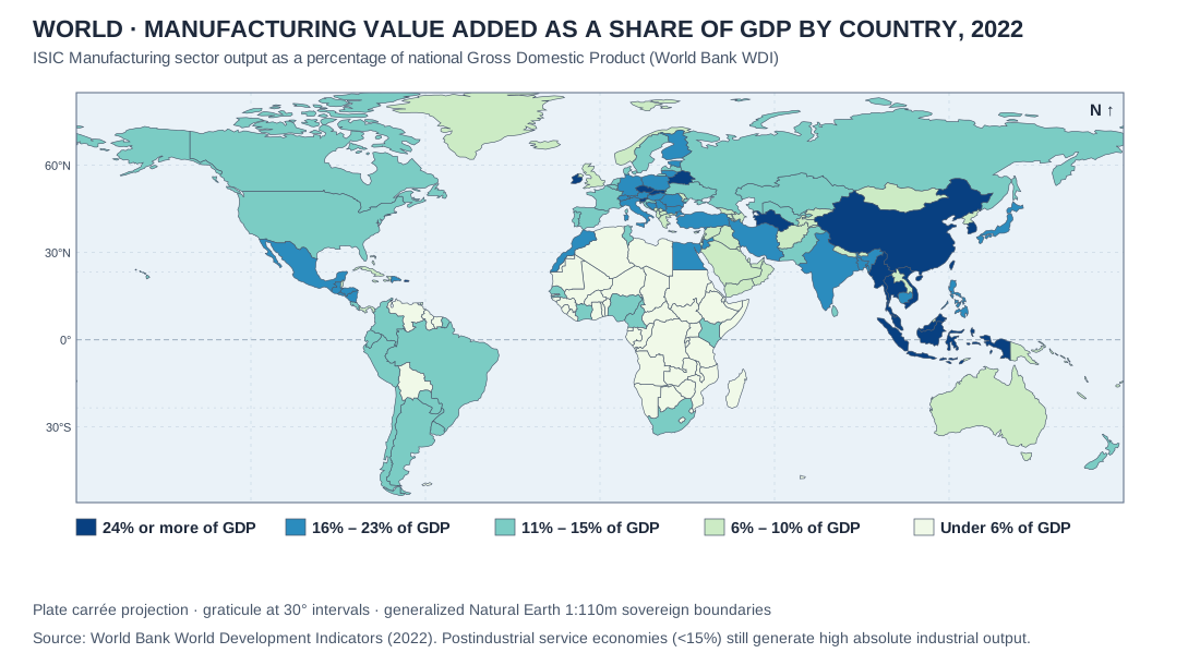
UNIT 7 · manufacturing-share-map
World · manufacturing value added as a share of GDP, 2022
- Credit and adaptations
- Data: World Bank, World Development Indicators (2022), manufacturing value added as a share of GDP, as stated in the map. Natural Earth 1:110m boundaries. Practice Dojo map.
- Reuse basis
- Natural Earth public-domain geometry; World Bank data charted by Practice Dojo.
- Source
- Original source
- Packaged asset SHA-256
- 1622435df1a14ae9611c7bc425cc764c0d1f4e95cf206e44c81d9ed66667209a
UNIT 7 · rostow-wallerstein
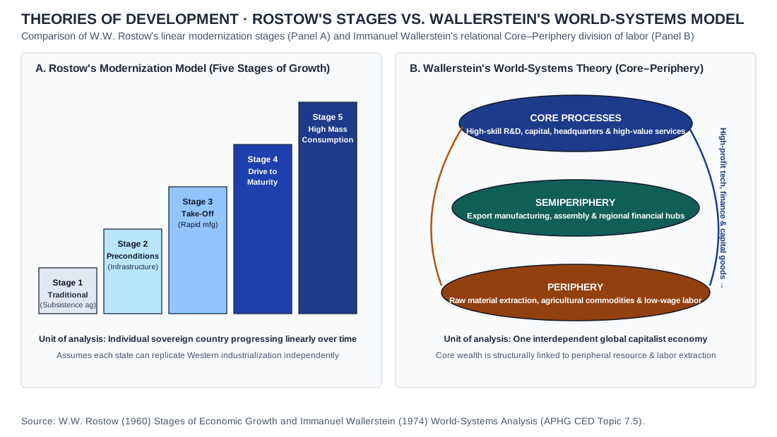
Theories of development · Rostow's modernization stages vs. Wallerstein's World-Systems model
- Credit and adaptations
- Practice Dojo original cartographic and analytical exhibit aligned to APHG CED Topic 7.5. Theories of development · Rostow's modernization stages vs. Wallerstein's World-Systems model.
- Reuse basis
- Original vector diagram / Natural Earth 1:110m public-domain geometry and documented public statistical series.
- Packaged asset SHA-256
- 2b96b6ec8f96d5e5a2f2c5d5ef30df0fb084183cc556c8952f6c3f00620687f1
UNIT 1 · u1-bb-projections-matrix
Comparative Properties of Four Map Projections
- Credit and adaptations
- Practice Dojo original analytical exhibit and comparative synthesis aligned to the AP Human Geography Course and Exam Description. Cartographic synthesis table comparing Mercator, Gall-Peters, Robinson/Winkel Tripel, and Azimuthal Equidistant projections across conformal, equal-area, and navigational properties (CED Topic 1.1).
- Reuse basis
- Original Practice Dojo tabular/vector synthesis compiled from public-domain UN, World Bank, Census, and standard AP Human Geography reference models; no third-party copyrighted artwork reproduced.
- Source
- AP Human Geography CED framework
UNIT 1 · u1-bb-geospatial-tech
Municipal Wildfire & Watershed Response: Geospatial Technology Matrix
- Credit and adaptations
- Practice Dojo original analytical exhibit and comparative synthesis aligned to the AP Human Geography Course and Exam Description. Comparative analytical matrix distinguishing Remote Sensing (LiDAR/Multispectral), GPS/GNSS positioning, GIS spatial overlay modeling, and Participatory GIS field verification (CED Topic 1.2–1.3).
- Reuse basis
- Original Practice Dojo tabular/vector synthesis compiled from public-domain UN, World Bank, Census, and standard AP Human Geography reference models; no third-party copyrighted artwork reproduced.
- Source
- AP Human Geography CED framework
UNIT 1 · u1-bb-maup-scale
Median Household Income & Poverty Rate by Scale of Aggregation (Metro X, 2024)
- Credit and adaptations
- Practice Dojo original analytical exhibit and comparative synthesis aligned to the AP Human Geography Course and Exam Description. Multi-scale statistical table illustrating the Modifiable Areal Unit Problem (MAUP) and ecological fallacy across metropolitan, municipal, census-tract, and block-group scales (CED Topic 1.6).
- Reuse basis
- Original Practice Dojo tabular/vector synthesis compiled from public-domain UN, World Bank, Census, and standard AP Human Geography reference models; no third-party copyrighted artwork reproduced.
- Source
- AP Human Geography CED framework
UNIT 1 · u1-bb-regional-typology
Comparative Regional Classification Matrix
- Credit and adaptations
- Practice Dojo original analytical exhibit and comparative synthesis aligned to the AP Human Geography Course and Exam Description. Analytical matrix comparing Formal (Uniform), Functional (Nodal), and Perceptual (Vernacular) regions across boundary mechanics, defining metrics, and spatial evolution (CED Topic 1.7).
- Reuse basis
- Original Practice Dojo tabular/vector synthesis compiled from public-domain UN, World Bank, Census, and standard AP Human Geography reference models; no third-party copyrighted artwork reproduced.
- Source
- AP Human Geography CED framework
UNIT 2 · u2-bb-density-matrix
Comparative Demographic & Agricultural Density Matrix (2024)
- Credit and adaptations
- Practice Dojo original analytical exhibit and comparative synthesis aligned to the AP Human Geography Course and Exam Description. Cross-national comparison of arithmetic, physiological, and agricultural densities across River Basin Alpha, Highland Beta, Polder Gamma, and Prairie Delta (CED Topic 2.1–2.2).
- Reuse basis
- Original Practice Dojo tabular/vector synthesis compiled from public-domain UN, World Bank, Census, and standard AP Human Geography reference models; no third-party copyrighted artwork reproduced.
- Source
- AP Human Geography CED framework
UNIT 2 · u2-bb-cohort-balancing
Age-Structure & Demographic Balancing Profile (2024)
- Credit and adaptations
- Practice Dojo original analytical exhibit and comparative synthesis aligned to the AP Human Geography Course and Exam Description. Comparative demographic table of crude birth/death rates, net migration rates, median age, and youth vs. elderly dependency ratios across four representative states (CED Topic 2.3–2.4).
- Reuse basis
- Original Practice Dojo tabular/vector synthesis compiled from public-domain UN, World Bank, Census, and standard AP Human Geography reference models; no third-party copyrighted artwork reproduced.
- Source
- AP Human Geography CED framework
UNIT 2 · u2-bb-dtm-epidemiologic
Demographic & Epidemiologic Transition Synthesis Matrix
- Credit and adaptations
- Practice Dojo original analytical exhibit and comparative synthesis aligned to the AP Human Geography Course and Exam Description. Integrated five-stage matrix pairing Demographic Transition vital rates with Abdel Omran's Epidemiologic Transition mortality causes and Malthusian/Boserupian dynamics (CED Topic 2.5–2.6).
- Reuse basis
- Original Practice Dojo tabular/vector synthesis compiled from public-domain UN, World Bank, Census, and standard AP Human Geography reference models; no third-party copyrighted artwork reproduced.
- Source
- AP Human Geography CED framework
UNIT 2 · u2-bb-migration-typology
Global Mobility & Forced Displacement Corridors (2024)
- Credit and adaptations
- Practice Dojo original analytical exhibit and comparative synthesis aligned to the AP Human Geography Course and Exam Description. Comparative typology of international refugees, internally displaced persons (IDPs), Kafala guest workers, step/chain rural-to-urban migrants, and brain-drain flows (CED Topic 2.10–2.12).
- Reuse basis
- Original Practice Dojo tabular/vector synthesis compiled from public-domain UN, World Bank, Census, and standard AP Human Geography reference models; no third-party copyrighted artwork reproduced.
- Source
- AP Human Geography CED framework
UNIT 3 · u3-bb-landscape-matrix
Comparative Cultural Landscape & Sequent Occupance Matrix
- Credit and adaptations
- Practice Dojo original analytical exhibit and comparative synthesis aligned to the AP Human Geography Course and Exam Description. Analytical matrix of built morphology, sequent occupance layers, and toponymic shifts across Cusco, Córdoba, New Orleans, and Cyberjaya (CED Topic 3.1–3.2).
- Reuse basis
- Original Practice Dojo tabular/vector synthesis compiled from public-domain UN, World Bank, Census, and standard AP Human Geography reference models; no third-party copyrighted artwork reproduced.
- Source
- AP Human Geography CED framework
UNIT 3 · u3-bb-diffusion-matrix
Comparative Spatial Diffusion & Cultural Convergence Matrix
- Credit and adaptations
- Practice Dojo original analytical exhibit and comparative synthesis aligned to the AP Human Geography Course and Exam Description. Typology of relocation, hierarchical, reverse-hierarchical, contagious, and stimulus diffusion mechanisms and their impacts on local-global cultural convergence (CED Topic 3.4).
- Reuse basis
- Original Practice Dojo tabular/vector synthesis compiled from public-domain UN, World Bank, Census, and standard AP Human Geography reference models; no third-party copyrighted artwork reproduced.
- Source
- AP Human Geography CED framework
UNIT 3 · u3-bb-language-policy
Comparative Ethnolinguistic & Language Policy Matrix
- Credit and adaptations
- Practice Dojo original analytical exhibit and comparative synthesis aligned to the AP Human Geography Course and Exam Description. Cross-national synthesis of language families/branches, lingua francas, creolization, and constitutional language policies in Nigeria, Switzerland, Belgium, and New Zealand (CED Topic 3.5 & 3.7).
- Reuse basis
- Original Practice Dojo tabular/vector synthesis compiled from public-domain UN, World Bank, Census, and standard AP Human Geography reference models; no third-party copyrighted artwork reproduced.
- Source
- AP Human Geography CED framework
UNIT 3 · u3-bb-religious-matrix
Comparative Geography of Universalizing, Ethnic & Syncretic Faiths
- Credit and adaptations
- Practice Dojo original analytical exhibit and comparative synthesis aligned to the AP Human Geography Course and Exam Description. Matrix comparing hearth origins, diffusion pathways, pilgrimage landscapes, and calendar/architectural expressions across major world and syncretic religions (CED Topic 3.5 & 3.8).
- Reuse basis
- Original Practice Dojo tabular/vector synthesis compiled from public-domain UN, World Bank, Census, and standard AP Human Geography reference models; no third-party copyrighted artwork reproduced.
- Source
- AP Human Geography CED framework
UNIT 4 · u4-bb-entities-matrix
Comparative Political Entities & Sovereignty Matrix
- Credit and adaptations
- Practice Dojo original analytical exhibit and comparative synthesis aligned to the AP Human Geography Course and Exam Description. Analytical typology contrasting nation-states, multinational states, multistate nations, stateless nations, and autonomous territories (CED Topic 4.1–4.2).
- Reuse basis
- Original Practice Dojo tabular/vector synthesis compiled from public-domain UN, World Bank, Census, and standard AP Human Geography reference models; no third-party copyrighted artwork reproduced.
- Source
- AP Human Geography CED framework
UNIT 4 · u4-bb-boundary-matrix
Genetic & Functional Classification of Selected Political Boundaries
- Credit and adaptations
- Practice Dojo original analytical exhibit and comparative synthesis aligned to the AP Human Geography Course and Exam Description. Comparative matrix of antecedent, subsequent, consequent, superimposed, and relic boundaries alongside definitional, locational, operational, and allocational disputes (CED Topic 4.4–4.5).
- Reuse basis
- Original Practice Dojo tabular/vector synthesis compiled from public-domain UN, World Bank, Census, and standard AP Human Geography reference models; no third-party copyrighted artwork reproduced.
- Source
- AP Human Geography CED framework
UNIT 4 · u4-bb-governance-matrix
Comparative Constitutional Governance, Electoral Redistricting & Devolution Matrix
- Credit and adaptations
- Practice Dojo original analytical exhibit and comparative synthesis aligned to the AP Human Geography Course and Exam Description. Synthesis of unitary vs. federal states, asymmetric devolution, and electoral packing/cracking redistricting mechanics (CED Topic 4.6–4.8).
- Reuse basis
- Original Practice Dojo tabular/vector synthesis compiled from public-domain UN, World Bank, Census, and standard AP Human Geography reference models; no third-party copyrighted artwork reproduced.
- Source
- AP Human Geography CED framework
UNIT 4 · u4-bb-chokepoint-matrix
Maritime Chokepoints, UNCLOS Zones & Supranational Integration Matrix
- Credit and adaptations
- Practice Dojo original analytical exhibit and comparative synthesis aligned to the AP Human Geography Course and Exam Description. Analytical matrix covering UNCLOS 12-nm territorial seas, 200-nm EEZs, median-line straits, and supranational integration tiers (CED Topic 4.5 & 4.9).
- Reuse basis
- Original Practice Dojo tabular/vector synthesis compiled from public-domain UN, World Bank, Census, and standard AP Human Geography reference models; no third-party copyrighted artwork reproduced.
- Source
- AP Human Geography CED framework
UNIT 5 · u5-bb-systems-matrix
Comparative Global Agricultural Production Systems (2024)
- Credit and adaptations
- Practice Dojo original analytical exhibit and comparative synthesis aligned to the AP Human Geography Course and Exam Description. Cross-system matrix comparing labor/capital intensity, land abundance, bioclimatic zones, and market orientation across Whittlesey agricultural regions (CED Topic 5.1 & 5.6).
- Reuse basis
- Original Practice Dojo tabular/vector synthesis compiled from public-domain UN, World Bank, Census, and standard AP Human Geography reference models; no third-party copyrighted artwork reproduced.
- Source
- AP Human Geography CED framework
UNIT 5 · u5-bb-revolutions-matrix
Three Agricultural Revolutions & Technological Transitions Matrix
- Credit and adaptations
- Practice Dojo original analytical exhibit and comparative synthesis aligned to the AP Human Geography Course and Exam Description. Historical-geographical synthesis of the First (Neolithic hearths), Second (Enclosure/mechanization), and Third/Green (HYV/biotech) Agricultural Revolutions (CED Topic 5.3–5.5).
- Reuse basis
- Original Practice Dojo tabular/vector synthesis compiled from public-domain UN, World Bank, Census, and standard AP Human Geography reference models; no third-party copyrighted artwork reproduced.
- Source
- AP Human Geography CED framework
UNIT 5 · u5-bb-von-thunen-matrix
Von Thünen Bid-Rent Mechanics & Contemporary Commodity Chain Matrix
- Credit and adaptations
- Practice Dojo original analytical exhibit and comparative synthesis aligned to the AP Human Geography Course and Exam Description. Quantitative bid-rent gradient table and agribusiness value-chain distribution comparing farm-gate vs. core retail value capture (CED Topic 5.7–5.9).
- Reuse basis
- Original Practice Dojo tabular/vector synthesis compiled from public-domain UN, World Bank, Census, and standard AP Human Geography reference models; no third-party copyrighted artwork reproduced.
- Source
- AP Human Geography CED framework
UNIT 5 · u5-bb-sustainability-matrix
Agricultural Environmental Impacts, Food Insecurity & Gender Matrix
- Credit and adaptations
- Practice Dojo original analytical exhibit and comparative synthesis aligned to the AP Human Geography Course and Exam Description. Comparative synthesis of irrigation salinization, aquifer depletion, deforestation, urban food deserts, and female agricultural labor/tenure gaps (CED Topic 5.10–5.12).
- Reuse basis
- Original Practice Dojo tabular/vector synthesis compiled from public-domain UN, World Bank, Census, and standard AP Human Geography reference models; no third-party copyrighted artwork reproduced.
- Source
- AP Human Geography CED framework
UNIT 6 · u6-bb-hierarchy-matrix
Comparative Urban Systems & Central Place Matrix (2024)
- Credit and adaptations
- Practice Dojo original analytical exhibit and comparative synthesis aligned to the AP Human Geography Course and Exam Description. Synthesis comparing Primate City vs. Rank-Size Rule distributions and Christaller central-place threshold/range tiers from regional market towns to Alpha+ World Cities (CED Topic 6.3–6.4).
- Reuse basis
- Original Practice Dojo tabular/vector synthesis compiled from public-domain UN, World Bank, Census, and standard AP Human Geography reference models; no third-party copyrighted artwork reproduced.
- Source
- AP Human Geography CED framework
UNIT 6 · u6-bb-world-models-matrix
Comparative Global Urban Morphology Matrix
- Credit and adaptations
- Practice Dojo original analytical exhibit and comparative synthesis aligned to the AP Human Geography Course and Exam Description. Comparative structural matrix of Burgess Concentric, Galactic/Edge City, Griffin-Ford Latin American, De Blij Sub-Saharan African, and McGee Southeast Asian urban models (CED Topic 6.5).
- Reuse basis
- Original Practice Dojo tabular/vector synthesis compiled from public-domain UN, World Bank, Census, and standard AP Human Geography reference models; no third-party copyrighted artwork reproduced.
- Source
- AP Human Geography CED framework
UNIT 6 · u6-bb-bidrent-housing-matrix
Metropolitan Bid-Rent, Housing Density & Institutional Trajectory (Metro Gamma)
- Credit and adaptations
- Practice Dojo original analytical exhibit and comparative synthesis aligned to the AP Human Geography Course and Exam Description. Zonal profile from CBD to exurban fringe linking Alonso bid-rent land prices, floor-area ratios, 1930s HOLC redlining rent gaps, inner-ring suburban poverty, and Euclidean zoning (CED Topic 6.6 & 6.10).
- Reuse basis
- Original Practice Dojo tabular/vector synthesis compiled from public-domain UN, World Bank, Census, and standard AP Human Geography reference models; no third-party copyrighted artwork reproduced.
- Source
- AP Human Geography CED framework
UNIT 6 · u6-bb-sustainability-matrix
Comparative Urban Growth & Sustainability Scorecard (2024)
- Credit and adaptations
- Practice Dojo original analytical exhibit and comparative synthesis aligned to the AP Human Geography Course and Exam Description. Comparative metropolitan audit contrasting conventional highway sprawl with transit-oriented smart growth across land consumption, commute mode split, urban heat island, and eco-gentrification (CED Topic 6.7–6.11).
- Reuse basis
- Original Practice Dojo tabular/vector synthesis compiled from public-domain UN, World Bank, Census, and standard AP Human Geography reference models; no third-party copyrighted artwork reproduced.
- Source
- AP Human Geography CED framework
UNIT 6 · u6-site-situation-table
Comparative Urban Origins: Site vs. Situation
- Credit and adaptations
- Practice Dojo original analytical exhibit and comparative synthesis aligned to the AP Human Geography Course and Exam Description. Comparative table of local physical site attributes and regional/global situation connectivity for Singapore, Chicago, and Brasília (CED Topic 6.1).
- Reuse basis
- Original Practice Dojo tabular/vector synthesis compiled from public-domain UN, World Bank, Census, and standard AP Human Geography reference models; no third-party copyrighted artwork reproduced.
- Source
- AP Human Geography CED framework
UNIT 6 · u6-global-urbanization-svg
Projected Urban Population Growth by World Region (1950–2050)
- Credit and adaptations
- Practice Dojo original analytical exhibit and comparative synthesis aligned to the AP Human Geography Course and Exam Description. Time-series chart based on UN DESA World Urbanization Prospects comparing urban share levels and rates of urbanization across North America, Asia, and Sub-Saharan Africa (CED Topic 6.2).
- Reuse basis
- Original Practice Dojo tabular/vector synthesis compiled from public-domain UN, World Bank, Census, and standard AP Human Geography reference models; no third-party copyrighted artwork reproduced.
- Source
- AP Human Geography CED framework
UNIT 6 · u6-hoyt-sector-svg
Hoyt Sector Model of Urban Structure
- Credit and adaptations
- Practice Dojo original analytical exhibit and comparative synthesis aligned to the AP Human Geography Course and Exam Description. Conceptual diagram adapted from Homer Hoyt (1939) illustrating radial transport/industrial corridors and directional residential sectors (CED Topic 6.5).
- Reuse basis
- Original Practice Dojo tabular/vector synthesis compiled from public-domain UN, World Bank, Census, and standard AP Human Geography reference models; no third-party copyrighted artwork reproduced.
- Source
- AP Human Geography CED framework
UNIT 6 · u6-holc-redlining-excerpt
Home Owners' Loan Corporation (HOLC) Area Description — Philadelphia, PA (1937)
- Credit and adaptations
- Practice Dojo original analytical exhibit and comparative synthesis aligned to the AP Human Geography Course and Exam Description. Archival primary-source excerpt from the Federal Home Loan Bank Board HOLC City Survey Files illustrating fourth-grade ('Grade D') mortgage redlining criteria (CED Topic 6.10).
- Reuse basis
- Original Practice Dojo tabular/vector synthesis compiled from public-domain UN, World Bank, Census, and standard AP Human Geography reference models; no third-party copyrighted artwork reproduced.
- Source
- AP Human Geography CED framework
UNIT 7 · u7-bb-weber-sectors-matrix
Comparative Industrial Location & Sectoral Cost Matrix (Weberian Synthesis)
- Credit and adaptations
- Practice Dojo original analytical exhibit and comparative synthesis aligned to the AP Human Geography Course and Exam Description. Analytical table comparing raw-material vs. finished tonnage and labor cost shares across bulk-reducing copper smelting, bulk-gaining beverage bottling, footloose apparel, and quaternary biotech R&D (CED Topic 7.2).
- Reuse basis
- Original Practice Dojo tabular/vector synthesis compiled from public-domain UN, World Bank, Census, and standard AP Human Geography reference models; no third-party copyrighted artwork reproduced.
- Source
- AP Human Geography CED framework
UNIT 7 · u7-bb-development-indices-matrix
Comparative Multidimensional Development Profile (2024)
- Credit and adaptations
- Practice Dojo original analytical exhibit and comparative synthesis aligned to the AP Human Geography Course and Exam Description. Cross-national synthesis of GNI per capita (PPP), Gini coefficient, Human Development Index (HDI), Gender Inequality Index (GII), and informal employment shares across five development profiles (CED Topic 7.3–7.4).
- Reuse basis
- Original Practice Dojo tabular/vector synthesis compiled from public-domain UN, World Bank, Census, and standard AP Human Geography reference models; no third-party copyrighted artwork reproduced.
- Source
- AP Human Geography CED framework
UNIT 7 · u7-bb-theories-trade-matrix
Comparative Development Frameworks & Trade Strategies Matrix
- Credit and adaptations
- Practice Dojo original analytical exhibit and comparative synthesis aligned to the AP Human Geography Course and Exam Description. Comparative matrix of Rostow's Stages of Growth, Wallerstein's World-Systems Theory, Import Substitution Industrialization (ISI), and Export-Oriented Industrialization (EOI) (CED Topic 7.5–7.6).
- Reuse basis
- Original Practice Dojo tabular/vector synthesis compiled from public-domain UN, World Bank, Census, and standard AP Human Geography reference models; no third-party copyrighted artwork reproduced.
- Source
- AP Human Geography CED framework
UNIT 7 · u7-bb-postfordist-sustainability-matrix
Global Production Regimes & Sustainable Development Transitions
- Credit and adaptations
- Practice Dojo original analytical exhibit and comparative synthesis aligned to the AP Human Geography Course and Exam Description. Analytical matrix comparing Classic Fordism, Post-Fordist Just-in-Time Global Value Chains, and Circular Eco-Industrial Symbiosis Parks under UN SDGs 9 and 12 (CED Topic 7.7–7.8).
- Reuse basis
- Original Practice Dojo tabular/vector synthesis compiled from public-domain UN, World Bank, Census, and standard AP Human Geography reference models; no third-party copyrighted artwork reproduced.
- Source
- AP Human Geography CED framework
UNIT 7 · u7-clark-sectoral-svg
Sectoral Employment Shifts During Economic Development
- Credit and adaptations
- Practice Dojo original analytical exhibit and comparative synthesis aligned to the AP Human Geography Course and Exam Description. Conceptual line diagram adapted from the Clark-Fourastié sectoral model illustrating labor force transitions across primary, secondary, and tertiary/quaternary sectors (CED Topic 7.2).
- Reuse basis
- Original Practice Dojo tabular/vector synthesis compiled from public-domain UN, World Bank, Census, and standard AP Human Geography reference models; no third-party copyrighted artwork reproduced.
- Source
- AP Human Geography CED framework
UNIT 7 · u7-undp-hdi-table
Selected Economic and Social Development Indicators
- Credit and adaptations
- Practice Dojo original analytical exhibit and comparative synthesis aligned to the AP Human Geography Course and Exam Description. Comparative statistical table from UNDP Human Development Report series comparing GDP per capita (PPP), life expectancy, schooling, GII, and HDI across Norway, South Korea, Brazil, and Niger (CED Topic 7.3–7.4).
- Reuse basis
- Original Practice Dojo tabular/vector synthesis compiled from public-domain UN, World Bank, Census, and standard AP Human Geography reference models; no third-party copyrighted artwork reproduced.
- Source
- AP Human Geography CED framework
UNIT 7 · u7-rostow-takeoff-excerpt
W.W. Rostow's Stages of Economic Growth (1960)
- Credit and adaptations
- Practice Dojo original analytical exhibit and comparative synthesis aligned to the AP Human Geography Course and Exam Description. Historical excerpt from W.W. Rostow (1960) defining the 'Take-Off' stage of modernization (CED Topic 7.5).
- Reuse basis
- Original Practice Dojo tabular/vector synthesis compiled from public-domain UN, World Bank, Census, and standard AP Human Geography reference models; no third-party copyrighted artwork reproduced.
- Source
- AP Human Geography CED framework
UNIT 7 · u7-china-sez-table
China's Coastal Special Economic Zones (SEZs) and Open Coastal Cities
- Credit and adaptations
- Practice Dojo original analytical exhibit and comparative synthesis aligned to the AP Human Geography Course and Exam Description. Comparative geographical table of Shenzhen SEZ, Xiamen SEZ, and Shanghai Pudong New Area highlighting maritime port situation and export profiles (CED Topic 7.6–7.7).
- Reuse basis
- Original Practice Dojo tabular/vector synthesis compiled from public-domain UN, World Bank, Census, and standard AP Human Geography reference models; no third-party copyrighted artwork reproduced.
- Source
- AP Human Geography CED framework
Supporting reuse and model references
- Natural Earth public-domain terms
- NASA Earth Science imagery reuse
- EIA data reuse
- CC BY 2.0
- CC BY 3.0
- CC BY-SA 3.0
- CC BY-SA 4.0
- Urban models: York University
- Latin American model: Florida International University
- Agricultural location: College of DuPage
- Industrial location: Northern Virginia Community College