AP Human Geography › Unit 6
AP Human Geography Unit 6: Cities and Urban Land-Use Patterns and Processes
Most of the world's people now live in cities. This unit covers site and situation, world cities, the rank-size rule and central place theory, urban models such as Burgess, Hoyt, and Harris and Ullman, density, infrastructure, and sustainability. Exam questions often supply census data or a city map and ask you to explain a pattern. Students frequently confuse site, a city's physical setting, with situation, its connections to other places. Many also apply North American urban models to cities elsewhere without noting where they fit poorly.
Practice this unit
Topics in this unit
- 6.1 The Origin and Influences of Urbanization
- 6.2 Cities Across the World
- 6.3 Cities and Globalization
- 6.4 The Size and Distribution of Cities
- 6.5 The Internal Structure of Cities
- 6.6 Density and Land Use
- 6.7 Infrastructure
- 6.8 Urban Sustainability
- 6.9 Urban Data
- 6.10 Challenges of Urban Changes
- 6.11 Challenges of Urban Sustainability
Free-response questions
- Cities in a Global Hierarchy
- Gentrification and Neighborhood Change
- Models of North American Urban Structure
- Informal Settlements in Nairobi
- Sprawl and Smart Growth
Sample questions
These are taken from the Regular set, with the answer and explanation shown.
1. Many first-ring suburbs built in the 1950s now have aging houses, a shrinking tax base and rising poverty, while newer suburbs farther out keep growing. Which process best explains this pattern?
- AUrban growth boundaries have banned new building in the outer suburbs
- BGentrification has pushed high-income residents out of first-ring suburbs
- CSquatter settlements have spread into the first-ring suburbs from the core
- DMegacity growth has drawn residents from the suburbs into the central city
- EContinued sprawl pulls investment and wealthier households farther out
Answer: E. As metros keep spreading, new subdivisions, malls and office parks open at the edge. Wealthier households and businesses follow them. Older first-ring suburbs, with aging homes and stores, lose tax revenue and see poverty rise.
Common trap: Students pick gentrification. Gentrification brings wealthier residents in; here wealthier residents are leaving.
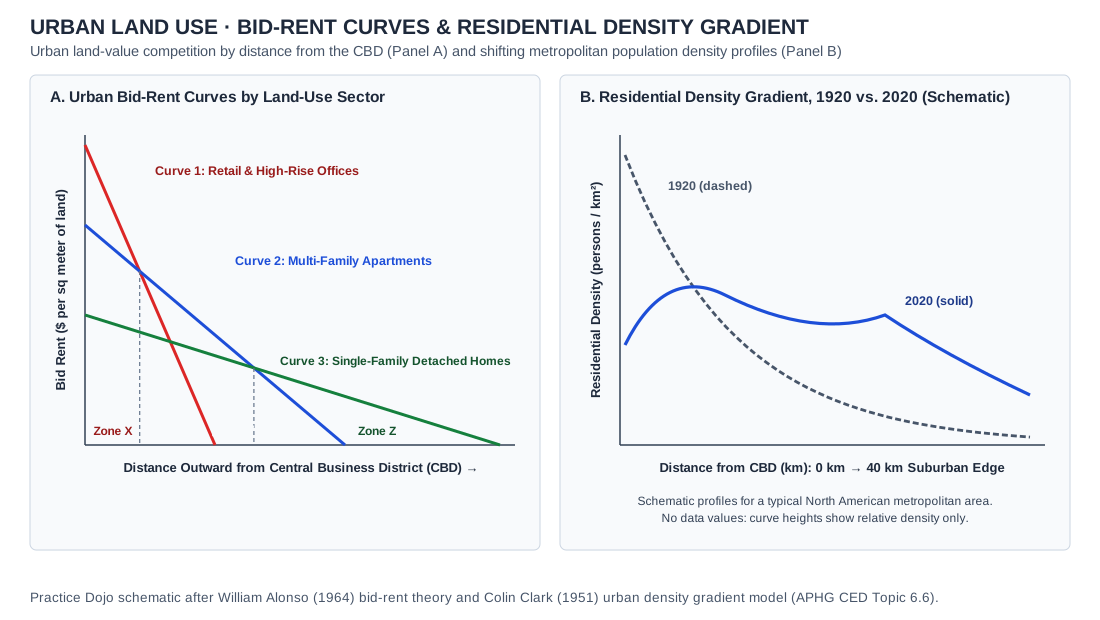
2. Which change from 1920 to 2020 does Panel B show, and what best explains it?
- ACore density rose as the CBD added high-rise housing, so fewer people lived in suburbs
- BDensity became the same at every distance because zoning required equal housing types
- CCore density fell and spread outward with a suburban peak as cars decentralized jobs
- DDensity fell at every distance from the CBD because the metro area lost population
- EDensity peaked only at the urban edge as farms were turned into high-rise apartments
Answer: C. The 2020 curve starts lower at the center, stays higher far from the CBD and rises again in the suburbs. Cars and highways let people live and work far from downtown, so density spread out. Offices and stores also moved to suburban centers.
Common trap: Students pick 'fell at every distance' because the 2020 curve is lower at the center. Away from the core, the 2020 curve is above the 1920 curve.
3. In the 1950s and 1960s, many U.S. cities used federal urban renewal funds to clear older inner-city neighborhoods labeled 'blighted' and replace them with highways, offices and public housing towers. Which evaluation of these projects is most accurate?
- AThey reduced suburbanization by drawing middle-class families back into the central city
- BThey raised home values for the original residents, who stayed in the rebuilt districts
- CThey were limited to vacant land, so few existing residents had to move to new places
- DThey added new buildings and roads but displaced many low-income, often Black, residents
- EThey mainly replaced farmland at the urban edge with new suburban housing tracts
Answer: D. Urban renewal had mixed results. It built new infrastructure and public buildings, but it demolished whole neighborhoods. Many displaced residents were low-income and Black, and close-knit communities were broken apart.
Common trap: Students pick 'raised home values for the original residents.' Most original residents were renters who were moved out, so they did not share in later gains.